You are here: Home > Network List > TA - USArray Transportable Network (new EarthScope stations) Stations List
> Station M14K Bethel, AK, USA > Earthquake Result Viewer
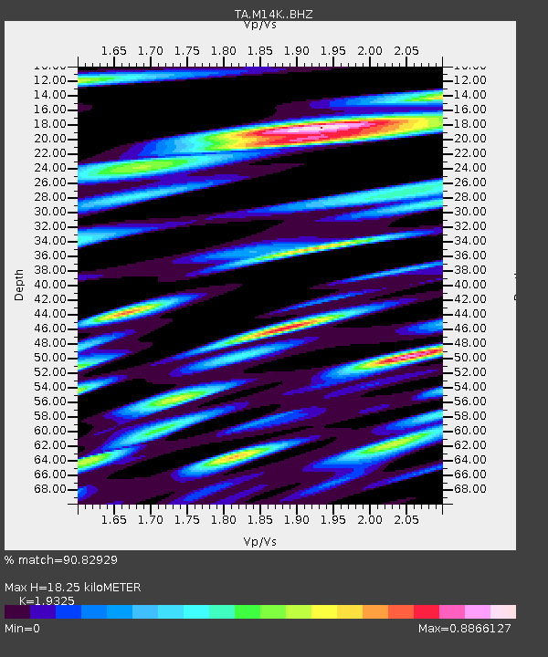
M14K Bethel, AK, USA - Earthquake Result Viewer
| Earthquake location: |
Ecuador |
| Earthquake latitude/longitude: |
-2.3/-78.9 |
| Earthquake time(UTC): |
2018/09/07 (250) 02:12:04 GMT |
| Earthquake Depth: |
94 km |
| Earthquake Magnitude: |
6.2 Mww |
| Earthquake Catalog/Contributor: |
NEIC PDE/us |
|
| Network: |
TA USArray Transportable Network (new EarthScope stations) |
| Station: |
M14K Bethel, AK, USA |
| Lat/Lon: |
60.75 N/161.96 W |
| Elevation: |
19 m |
|
| Distance: |
88.6 deg |
| Az: |
330.814 deg |
| Baz: |
97.186 deg |
| Ray Param: |
0.042249724 |
| Estimated Moho Depth: |
18.25 km |
| Estimated Crust Vp/Vs: |
1.93 |
| Assumed Crust Vp: |
6.182 km/s |
| Estimated Crust Vs: |
3.199 km/s |
| Estimated Crust Poisson's Ratio: |
0.32 |
|
| Radial Match: |
90.82929 % |
| Radial Bump: |
400 |
| Transverse Match: |
89.79837 % |
| Transverse Bump: |
400 |
| SOD ConfigId: |
13570011 |
| Insert Time: |
2019-05-01 04:02:02.447 +0000 |
| GWidth: |
2.5 |
| Max Bumps: |
400 |
| Tol: |
0.001 |
|

Signal To Noise
| Channel | StoN | STA | LTA |
| TA:M14K: :BHZ:20180907T02:24:15.824976Z | 39.92183 | 3.441718E-6 | 8.621143E-8 |
| TA:M14K: :BHN:20180907T02:24:15.824976Z | 7.363507 | 8.6583293E-7 | 1.1758432E-7 |
| TA:M14K: :BHE:20180907T02:24:15.824976Z | 10.883473 | 1.330006E-6 | 1.2220418E-7 |
| Arrivals |
| Ps | 2.8 SECOND |
| PpPs | 8.5 SECOND |
| PsPs/PpSs | 11 SECOND |


