You are here: Home > Network List > TA - USArray Transportable Network (new EarthScope stations) Stations List
> Station M26K Nabesna, AK, USA > Earthquake Result Viewer
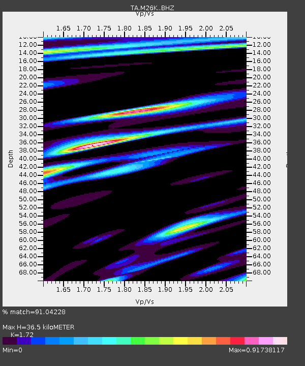
M26K Nabesna, AK, USA - Earthquake Result Viewer
| Earthquake location: |
Ecuador |
| Earthquake latitude/longitude: |
-2.3/-78.9 |
| Earthquake time(UTC): |
2018/09/07 (250) 02:12:04 GMT |
| Earthquake Depth: |
94 km |
| Earthquake Magnitude: |
6.2 Mww |
| Earthquake Catalog/Contributor: |
NEIC PDE/us |
|
| Network: |
TA USArray Transportable Network (new EarthScope stations) |
| Station: |
M26K Nabesna, AK, USA |
| Lat/Lon: |
62.40 N/143.00 W |
| Elevation: |
888 m |
|
| Distance: |
80.4 deg |
| Az: |
334.853 deg |
| Baz: |
114.263 deg |
| Ray Param: |
0.04812081 |
| Estimated Moho Depth: |
36.5 km |
| Estimated Crust Vp/Vs: |
1.72 |
| Assumed Crust Vp: |
6.566 km/s |
| Estimated Crust Vs: |
3.818 km/s |
| Estimated Crust Poisson's Ratio: |
0.24 |
|
| Radial Match: |
91.04228 % |
| Radial Bump: |
400 |
| Transverse Match: |
83.75235 % |
| Transverse Bump: |
400 |
| SOD ConfigId: |
13570011 |
| Insert Time: |
2019-05-01 04:02:10.608 +0000 |
| GWidth: |
2.5 |
| Max Bumps: |
400 |
| Tol: |
0.001 |
|

Signal To Noise
| Channel | StoN | STA | LTA |
| TA:M26K: :BHZ:20180907T02:23:34.375024Z | 42.125042 | 2.1594767E-6 | 5.1263488E-8 |
| TA:M26K: :BHN:20180907T02:23:34.375024Z | 6.3390727 | 5.681144E-7 | 8.9621054E-8 |
| TA:M26K: :BHE:20180907T02:23:34.375024Z | 11.573563 | 6.776067E-7 | 5.85478E-8 |
| Arrivals |
| Ps | 4.1 SECOND |
| PpPs | 15 SECOND |
| PsPs/PpSs | 19 SECOND |


