You are here: Home > Network List > TA - USArray Transportable Network (new EarthScope stations) Stations List
> Station B12A Libby, MT, USA > Earthquake Result Viewer
B12A Libby, MT, USA - Earthquake Result Viewer
| Earthquake location: |
Vanuatu Islands |
| Earthquake latitude/longitude: |
-15.4/168.6 |
| Earthquake time(UTC): |
2007/07/15 (196) 09:27:34 GMT |
| Earthquake Depth: |
8.0 km |
| Earthquake Magnitude: |
6.0 MB, 5.8 MS, 6.1 MW, 6.0 MW |
| Earthquake Catalog/Contributor: |
WHDF/NEIC |
|
| Network: |
TA USArray Transportable Network (new EarthScope stations) |
| Station: |
B12A Libby, MT, USA |
| Lat/Lon: |
48.47 N/115.59 W |
| Elevation: |
764 m |
|
| Distance: |
92.3 deg |
| Az: |
40.22 deg |
| Baz: |
249.38 deg |
| Ray Param: |
0.04148583 |
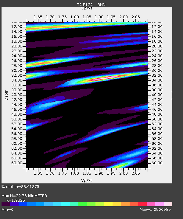
| Estimated Moho Depth: |
32.75 km |
| Estimated Crust Vp/Vs: |
1.93 |
| Assumed Crust Vp: |
6.622 km/s |
| Estimated Crust Vs: |
3.427 km/s |
| Estimated Crust Poisson's Ratio: |
0.32 |
|
| Radial Match: |
88.01375 % |
| Radial Bump: |
400 |
| Transverse Match: |
70.19985 % |
| Transverse Bump: |
400 |
| SOD ConfigId: |
2564 |
| Insert Time: |
2010-03-06 15:29:22.440 +0000 |
| GWidth: |
2.5 |
| Max Bumps: |
400 |
| Tol: |
0.001 |
|
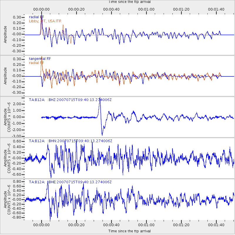
Signal To Noise
| Channel | StoN | STA | LTA |
| TA:B12A: :BHN:20070715T09:40:13.274006Z | 1.5893037 | 1.8474765E-7 | 1.162444E-7 |
| TA:B12A: :BHE:20070715T09:40:13.274006Z | 3.915569 | 3.2877398E-7 | 8.396582E-8 |
| TA:B12A: :BHZ:20070715T09:40:13.274006Z | 15.132436 | 1.2866168E-6 | 8.502378E-8 |
| Arrivals |
| Ps | 4.7 SECOND |
| PpPs | 14 SECOND |
| PsPs/PpSs | 19 SECOND |


