You are here: Home > Network List > TA - USArray Transportable Network (new EarthScope stations) Stations List
> Station N20K Mount Spurr, AK, USA > Earthquake Result Viewer
N20K Mount Spurr, AK, USA - Earthquake Result Viewer
| Earthquake location: |
Ecuador |
| Earthquake latitude/longitude: |
-2.3/-78.9 |
| Earthquake time(UTC): |
2018/09/07 (250) 02:12:04 GMT |
| Earthquake Depth: |
94 km |
| Earthquake Magnitude: |
6.2 Mww |
| Earthquake Catalog/Contributor: |
NEIC PDE/us |
|
| Network: |
TA USArray Transportable Network (new EarthScope stations) |
| Station: |
N20K Mount Spurr, AK, USA |
| Lat/Lon: |
61.20 N/152.21 W |
| Elevation: |
991 m |
|
| Distance: |
84.1 deg |
| Az: |
332.203 deg |
| Baz: |
105.793 deg |
| Ray Param: |
0.045549385 |
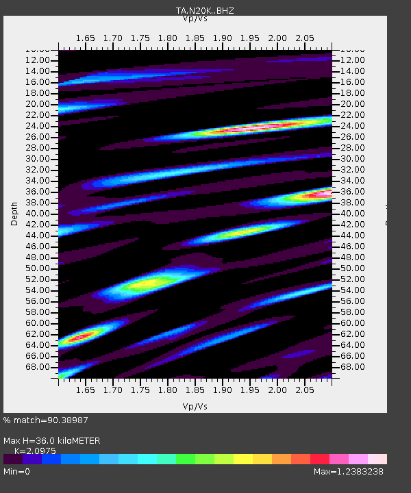
| Estimated Moho Depth: |
36.0 km |
| Estimated Crust Vp/Vs: |
2.10 |
| Assumed Crust Vp: |
6.566 km/s |
| Estimated Crust Vs: |
3.13 km/s |
| Estimated Crust Poisson's Ratio: |
0.35 |
|
| Radial Match: |
90.38987 % |
| Radial Bump: |
400 |
| Transverse Match: |
90.435196 % |
| Transverse Bump: |
400 |
| SOD ConfigId: |
13570011 |
| Insert Time: |
2019-05-01 04:02:21.449 +0000 |
| GWidth: |
2.5 |
| Max Bumps: |
400 |
| Tol: |
0.001 |
|

Signal To Noise
| Channel | StoN | STA | LTA |
| TA:N20K: :BHZ:20180907T02:23:53.574976Z | 36.939705 | 2.3712937E-6 | 6.419362E-8 |
| TA:N20K: :BHN:20180907T02:23:53.574976Z | 9.436865 | 6.447172E-7 | 6.8319004E-8 |
| TA:N20K: :BHE:20180907T02:23:53.574976Z | 11.102088 | 1.0486583E-6 | 9.445596E-8 |
| Arrivals |
| Ps | 6.2 SECOND |
| PpPs | 17 SECOND |
| PsPs/PpSs | 23 SECOND |


