You are here: Home > Network List > TA - USArray Transportable Network (new EarthScope stations) Stations List
> Station O17K Koliganek, Bristol Bay, AK, USA > Earthquake Result Viewer
O17K Koliganek, Bristol Bay, AK, USA - Earthquake Result Viewer
| Earthquake location: |
Ecuador |
| Earthquake latitude/longitude: |
-2.3/-78.9 |
| Earthquake time(UTC): |
2018/09/07 (250) 02:12:04 GMT |
| Earthquake Depth: |
94 km |
| Earthquake Magnitude: |
6.2 Mww |
| Earthquake Catalog/Contributor: |
NEIC PDE/us |
|
| Network: |
TA USArray Transportable Network (new EarthScope stations) |
| Station: |
O17K Koliganek, Bristol Bay, AK, USA |
| Lat/Lon: |
59.77 N/157.09 W |
| Elevation: |
156 m |
|
| Distance: |
86.1 deg |
| Az: |
330.237 deg |
| Baz: |
101.378 deg |
| Ray Param: |
0.04411373 |
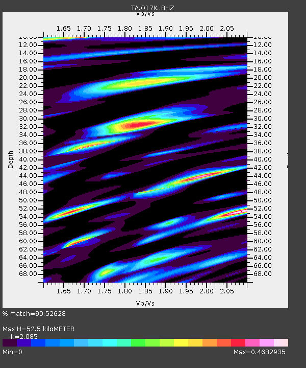
| Estimated Moho Depth: |
52.5 km |
| Estimated Crust Vp/Vs: |
2.09 |
| Assumed Crust Vp: |
6.276 km/s |
| Estimated Crust Vs: |
3.01 km/s |
| Estimated Crust Poisson's Ratio: |
0.35 |
|
| Radial Match: |
90.52628 % |
| Radial Bump: |
400 |
| Transverse Match: |
83.191574 % |
| Transverse Bump: |
400 |
| SOD ConfigId: |
13570011 |
| Insert Time: |
2019-05-01 04:02:28.118 +0000 |
| GWidth: |
2.5 |
| Max Bumps: |
400 |
| Tol: |
0.001 |
|
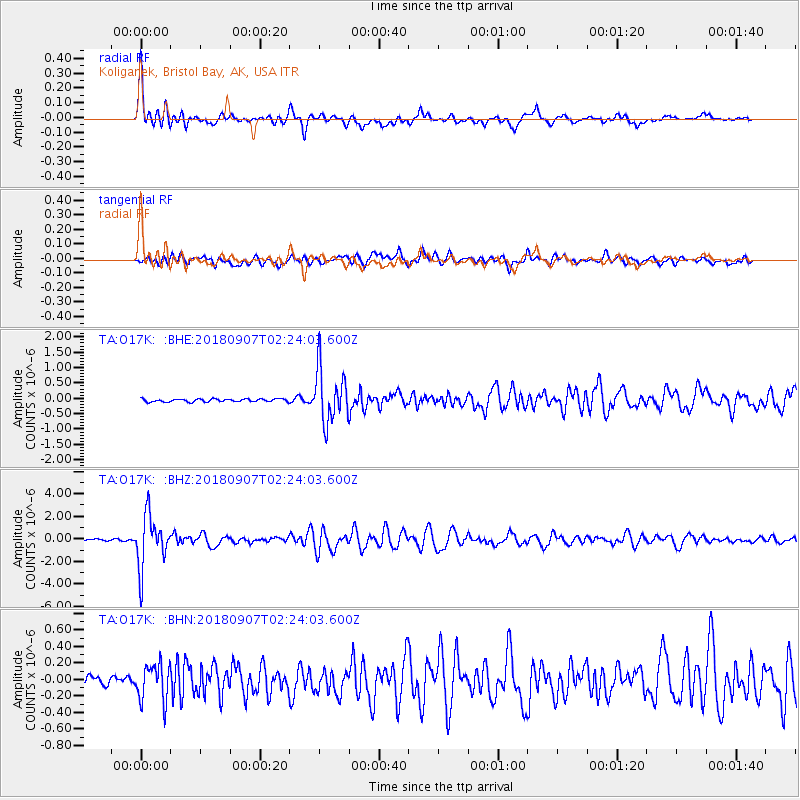
Signal To Noise
| Channel | StoN | STA | LTA |
| TA:O17K: :BHZ:20180907T02:24:03.600Z | 36.315693 | 2.3070163E-6 | 6.3526706E-8 |
| TA:O17K: :BHN:20180907T02:24:03.600Z | 2.8975723 | 2.2585527E-7 | 7.794638E-8 |
| TA:O17K: :BHE:20180907T02:24:03.600Z | 18.671679 | 8.64839E-7 | 4.6318227E-8 |
| Arrivals |
| Ps | 9.2 SECOND |
| PpPs | 25 SECOND |
| PsPs/PpSs | 35 SECOND |


