You are here: Home > Network List > TA - USArray Transportable Network (new EarthScope stations) Stations List
> Station B12A Libby, MT, USA > Earthquake Result Viewer
B12A Libby, MT, USA - Earthquake Result Viewer
| Earthquake location: |
North Of Svalbard |
| Earthquake latitude/longitude: |
80.3/-1.9 |
| Earthquake time(UTC): |
2009/03/06 (065) 10:50:29 GMT |
| Earthquake Depth: |
9.0 km |
| Earthquake Magnitude: |
6.6 MB, 6.5 MS, 6.5 MW, 6.4 MW |
| Earthquake Catalog/Contributor: |
WHDF/NEIC |
|
| Network: |
TA USArray Transportable Network (new EarthScope stations) |
| Station: |
B12A Libby, MT, USA |
| Lat/Lon: |
48.47 N/115.59 W |
| Elevation: |
764 m |
|
| Distance: |
46.3 deg |
| Az: |
302.646 deg |
| Baz: |
12.36 deg |
| Ray Param: |
0.07070406 |
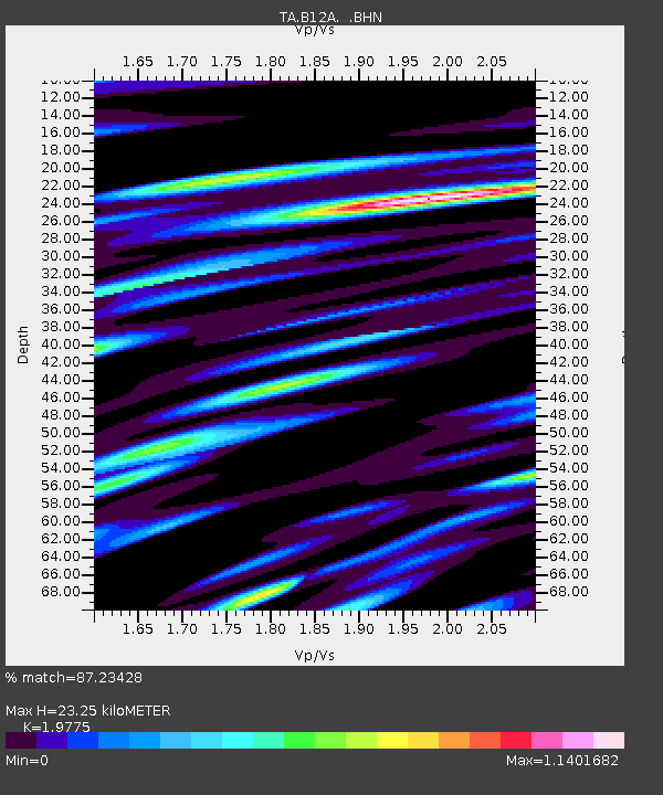
| Estimated Moho Depth: |
23.25 km |
| Estimated Crust Vp/Vs: |
1.98 |
| Assumed Crust Vp: |
6.622 km/s |
| Estimated Crust Vs: |
3.349 km/s |
| Estimated Crust Poisson's Ratio: |
0.33 |
|
| Radial Match: |
87.23428 % |
| Radial Bump: |
400 |
| Transverse Match: |
76.8332 % |
| Transverse Bump: |
400 |
| SOD ConfigId: |
2658 |
| Insert Time: |
2010-03-06 15:29:42.397 +0000 |
| GWidth: |
2.5 |
| Max Bumps: |
400 |
| Tol: |
0.001 |
|

Signal To Noise
| Channel | StoN | STA | LTA |
| TA:B12A: :BHN:20090306T10:58:24.748989Z | 33.779106 | 5.4791426E-6 | 1.6220507E-7 |
| TA:B12A: :BHE:20090306T10:58:24.748989Z | 19.846592 | 3.021774E-6 | 1.5225658E-7 |
| TA:B12A: :BHZ:20090306T10:58:24.748989Z | 3.963975 | 7.5220504E-7 | 1.8976029E-7 |
| Arrivals |
| Ps | 3.6 SECOND |
| PpPs | 9.8 SECOND |
| PsPs/PpSs | 13 SECOND |


