You are here: Home > Network List > TA - USArray Transportable Network (new EarthScope stations) Stations List
> Station B12A Libby, MT, USA > Earthquake Result Viewer
B12A Libby, MT, USA - Earthquake Result Viewer
| Earthquake location: |
Panama |
| Earthquake latitude/longitude: |
9.6/-79.0 |
| Earthquake time(UTC): |
2009/07/04 (185) 06:49:35 GMT |
| Earthquake Depth: |
38 km |
| Earthquake Magnitude: |
6.0 MB, 5.5 MS, 6.0 MW, 6.0 MW |
| Earthquake Catalog/Contributor: |
WHDF/NEIC |
|
| Network: |
TA USArray Transportable Network (new EarthScope stations) |
| Station: |
B12A Libby, MT, USA |
| Lat/Lon: |
48.47 N/115.59 W |
| Elevation: |
764 m |
|
| Distance: |
49.4 deg |
| Az: |
328.493 deg |
| Baz: |
129.247 deg |
| Ray Param: |
0.06862201 |
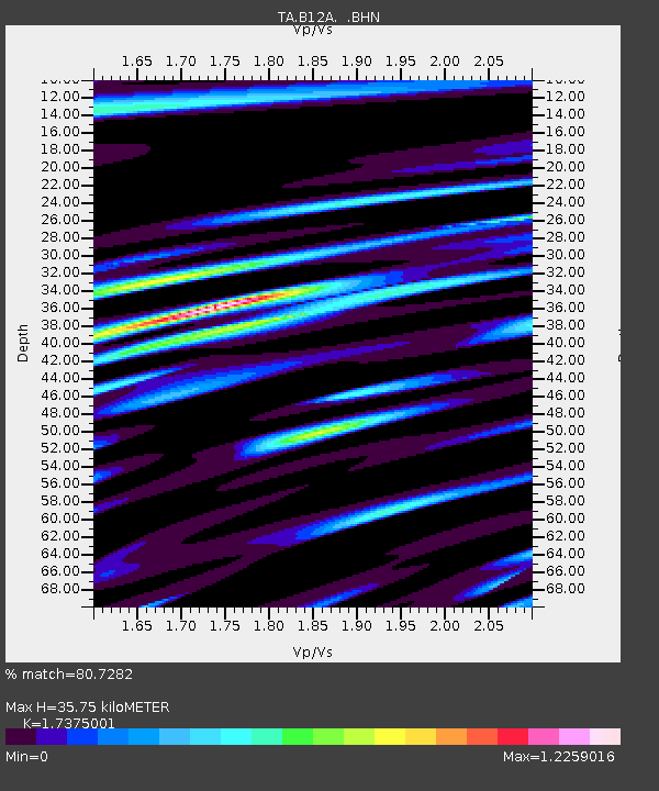
| Estimated Moho Depth: |
35.75 km |
| Estimated Crust Vp/Vs: |
1.74 |
| Assumed Crust Vp: |
6.622 km/s |
| Estimated Crust Vs: |
3.811 km/s |
| Estimated Crust Poisson's Ratio: |
0.25 |
|
| Radial Match: |
80.7282 % |
| Radial Bump: |
400 |
| Transverse Match: |
81.385735 % |
| Transverse Bump: |
400 |
| SOD ConfigId: |
2648 |
| Insert Time: |
2010-03-06 15:29:54.028 +0000 |
| GWidth: |
2.5 |
| Max Bumps: |
400 |
| Tol: |
0.001 |
|

Signal To Noise
| Channel | StoN | STA | LTA |
| TA:B12A: :BHN:20090704T06:57:51.200002Z | 11.075563 | 7.0173985E-7 | 6.3359295E-8 |
| TA:B12A: :BHE:20090704T06:57:51.200002Z | 5.3830466 | 2.538803E-7 | 4.716294E-8 |
| TA:B12A: :BHZ:20090704T06:57:51.200002Z | 4.5084467 | 3.2784138E-7 | 7.271714E-8 |
| Arrivals |
| Ps | 4.2 SECOND |
| PpPs | 14 SECOND |
| PsPs/PpSs | 18 SECOND |


