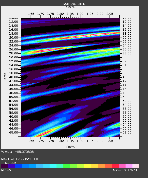
B12A Libby, MT, USA - Earthquake Result Viewer

Earthquake location: Rat Islands, Aleutian Islands
Earthquake latitude/longitude: 50.4/177.0
Earthquake time(UTC): 2009/07/06 (187) 14:53:12 GMT
Earthquake Depth: 22 km
Earthquake Magnitude: 6.0 MB, 5.8 MS, 6.1 MW, 6.0 MW
Earthquake Catalog/Contributor: WHDF/NEIC
Network: TA USArray Transportable Network (new EarthScope stations)
Station: B12A Libby, MT, USA
Lat/Lon: 48.47 N/115.59 W
Elevation: 764 m
Distance: 42.5 deg
Az: 65.438 deg
Baz: 299.079 deg
Ray Param: 0.07310733
Estimated Moho Depth: 18.75 km
Estimated Crust Vp/Vs: 1.95
Assumed Crust Vp: 6.622 km/s
Estimated Crust Vs: 3.396 km/s
Estimated Crust Poisson's Ratio: 0.32
Radial Match: 85.373535 %
Radial Bump: 400
Transverse Match: 78.4362 %
Transverse Bump: 400
SOD ConfigId: 2648
Insert Time: 2010-03-06 15:29:57.914 +0000
GWidth: 2.5
Max Bumps: 400
Tol: 0.001

Signal To Noise

ChannelStoNSTALTA
TA:B12A: :BHN:20090706T15:00:35.074015Z28.6664472.7908495E-69.7355965E-8
TA:B12A: :BHE:20090706T15:00:35.074015Z4.37909467.242344E-71.6538449E-7
TA:B12A: :BHZ:20090706T15:00:35.074015Z10.5211691.4908591E-61.417009E-7
Arrivals
Ps2.9 SECOND
PpPs7.8 SECOND
PsPs/PpSs11 SECOND