You are here: Home > Network List > TA - USArray Transportable Network (new EarthScope stations) Stations List
> Station B12A Libby, MT, USA > Earthquake Result Viewer
B12A Libby, MT, USA - Earthquake Result Viewer
| Earthquake location: |
Kuril Islands |
| Earthquake latitude/longitude: |
46.3/153.3 |
| Earthquake time(UTC): |
2006/10/13 (286) 13:47:39 GMT |
| Earthquake Depth: |
8.0 km |
| Earthquake Magnitude: |
5.5 MB, 5.8 MS, 6.3 MW, 5.8 MW |
| Earthquake Catalog/Contributor: |
WHDF/NEIC |
|
| Network: |
TA USArray Transportable Network (new EarthScope stations) |
| Station: |
B12A Libby, MT, USA |
| Lat/Lon: |
48.47 N/115.59 W |
| Elevation: |
764 m |
|
| Distance: |
58.1 deg |
| Az: |
51.599 deg |
| Baz: |
305.202 deg |
| Ray Param: |
0.06306427 |
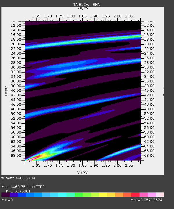
| Estimated Moho Depth: |
69.75 km |
| Estimated Crust Vp/Vs: |
1.62 |
| Assumed Crust Vp: |
6.622 km/s |
| Estimated Crust Vs: |
4.094 km/s |
| Estimated Crust Poisson's Ratio: |
0.19 |
|
| Radial Match: |
88.6784 % |
| Radial Bump: |
350 |
| Transverse Match: |
73.72811 % |
| Transverse Bump: |
365 |
| SOD ConfigId: |
2665 |
| Insert Time: |
2010-03-06 15:30:05.081 +0000 |
| GWidth: |
2.5 |
| Max Bumps: |
400 |
| Tol: |
0.001 |
|

Signal To Noise
| Channel | StoN | STA | LTA |
| TA:B12A: :BHN:20061013T13:57:02.65001Z | 1.5498505 | 2.930224E-7 | 1.8906495E-7 |
| TA:B12A: :BHE:20061013T13:57:02.65001Z | 0.7976156 | 1.710845E-7 | 2.1449492E-7 |
| TA:B12A: :BHZ:20061013T13:57:02.65001Z | 2.0580544 | 5.099981E-7 | 2.478059E-7 |
| Arrivals |
| Ps | 6.9 SECOND |
| PpPs | 26 SECOND |
| PsPs/PpSs | 33 SECOND |


