You are here: Home > Network List > UW - Pacific Northwest Regional Seismic Network Stations List
> Station YPT Yellepit > Earthquake Result Viewer
YPT Yellepit - Earthquake Result Viewer
| Earthquake location: |
Ecuador |
| Earthquake latitude/longitude: |
-2.3/-78.9 |
| Earthquake time(UTC): |
2018/09/07 (250) 02:12:04 GMT |
| Earthquake Depth: |
94 km |
| Earthquake Magnitude: |
6.2 Mww |
| Earthquake Catalog/Contributor: |
NEIC PDE/us |
|
| Network: |
UW Pacific Northwest Regional Seismic Network |
| Station: |
YPT Yellepit |
| Lat/Lon: |
46.05 N/118.96 W |
| Elevation: |
330 m |
|
| Distance: |
59.8 deg |
| Az: |
328.746 deg |
| Baz: |
131.897 deg |
| Ray Param: |
0.061703727 |
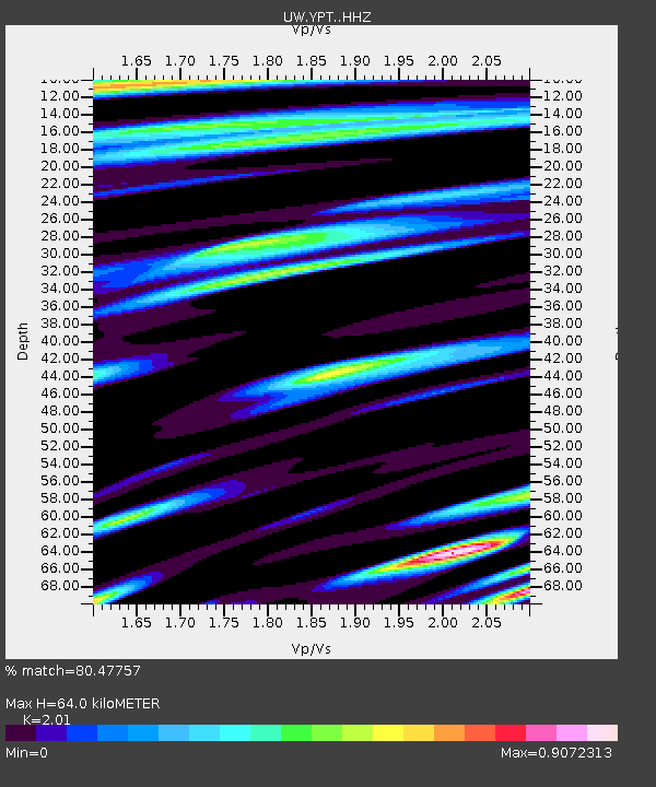
| Estimated Moho Depth: |
64.0 km |
| Estimated Crust Vp/Vs: |
2.01 |
| Assumed Crust Vp: |
6.419 km/s |
| Estimated Crust Vs: |
3.194 km/s |
| Estimated Crust Poisson's Ratio: |
0.34 |
|
| Radial Match: |
80.47757 % |
| Radial Bump: |
400 |
| Transverse Match: |
59.760532 % |
| Transverse Bump: |
400 |
| SOD ConfigId: |
13570011 |
| Insert Time: |
2019-05-01 04:04:26.443 +0000 |
| GWidth: |
2.5 |
| Max Bumps: |
400 |
| Tol: |
0.001 |
|

Signal To Noise
| Channel | StoN | STA | LTA |
| UW:YPT: :HHZ:20180907T02:21:28.920007Z | 21.618797 | 2.2448903E-6 | 1.0383973E-7 |
| UW:YPT: :HHN:20180907T02:21:28.920007Z | 7.6277723 | 5.9855034E-7 | 7.8469874E-8 |
| UW:YPT: :HHE:20180907T02:21:28.920007Z | 8.560315 | 9.573137E-7 | 1.1183159E-7 |
| Arrivals |
| Ps | 10 SECOND |
| PpPs | 29 SECOND |
| PsPs/PpSs | 39 SECOND |


