You are here: Home > Network List > TA - USArray Transportable Network (new EarthScope stations) Stations List
> Station B12A Libby, MT, USA > Earthquake Result Viewer
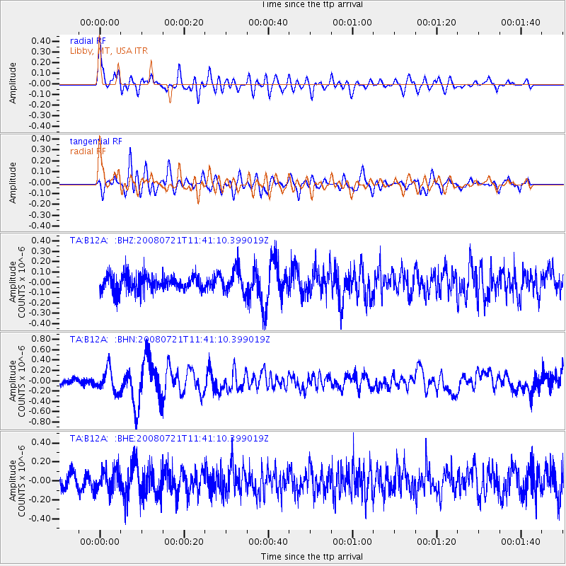
B12A Libby, MT, USA - Earthquake Result Viewer
*The percent match for this event was below the threshold and hence no stack was calculated.
| Earthquake location: |
Off East Coast Of Honshu, Japan |
| Earthquake latitude/longitude: |
37.2/142.1 |
| Earthquake time(UTC): |
2008/07/21 (203) 11:30:29 GMT |
| Earthquake Depth: |
22 km |
| Earthquake Magnitude: |
5.7 MB, 5.6 MS, 6.0 MW, 5.9 MW |
| Earthquake Catalog/Contributor: |
WHDF/NEIC |
|
| Network: |
TA USArray Transportable Network (new EarthScope stations) |
| Station: |
B12A Libby, MT, USA |
| Lat/Lon: |
48.47 N/115.59 W |
| Elevation: |
764 m |
|
| Distance: |
70.4 deg |
| Az: |
43.635 deg |
| Baz: |
304.097 deg |
| Ray Param: |
$rayparam |
*The percent match for this event was below the threshold and hence was not used in the summary stack. |
|
| Radial Match: |
77.028885 % |
| Radial Bump: |
400 |
| Transverse Match: |
68.12886 % |
| Transverse Bump: |
400 |
| SOD ConfigId: |
2504 |
| Insert Time: |
2010-03-06 15:30:29.408 +0000 |
| GWidth: |
2.5 |
| Max Bumps: |
400 |
| Tol: |
0.001 |
|
Signal To Noise
| Channel | StoN | STA | LTA |
| TA:B12A: :BHN:20080721T11:41:10.399019Z | 2.765288 | 2.2367858E-7 | 8.088798E-8 |
| TA:B12A: :BHE:20080721T11:41:10.399019Z | 0.95509064 | 1.10300356E-7 | 1.1548679E-7 |
| TA:B12A: :BHZ:20080721T11:41:10.399019Z | 1.4988104 | 1.1440148E-7 | 7.6328185E-8 |
| Arrivals |
| Ps | |
| PpPs | |
| PsPs/PpSs | |


