You are here: Home > Network List > TA - USArray Transportable Network (new EarthScope stations) Stations List
> Station B12A Libby, MT, USA > Earthquake Result Viewer
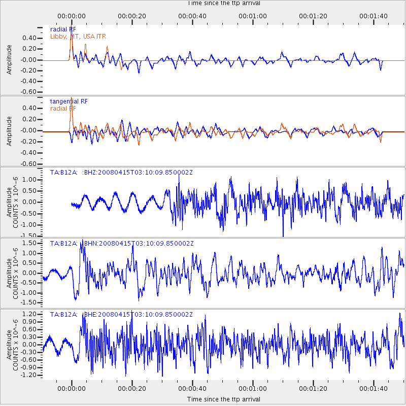
B12A Libby, MT, USA - Earthquake Result Viewer
*The percent match for this event was below the threshold and hence no stack was calculated.
| Earthquake location: |
Near Coast Of Guatemala |
| Earthquake latitude/longitude: |
13.6/-90.6 |
| Earthquake time(UTC): |
2008/04/15 (106) 03:03:04 GMT |
| Earthquake Depth: |
33 km |
| Earthquake Magnitude: |
5.6 MB, 5.8 MS, 6.1 MW, 6.1 MW |
| Earthquake Catalog/Contributor: |
WHDF/NEIC |
|
| Network: |
TA USArray Transportable Network (new EarthScope stations) |
| Station: |
B12A Libby, MT, USA |
| Lat/Lon: |
48.47 N/115.59 W |
| Elevation: |
764 m |
|
| Distance: |
40.5 deg |
| Az: |
334.341 deg |
| Baz: |
140.748 deg |
| Ray Param: |
$rayparam |
*The percent match for this event was below the threshold and hence was not used in the summary stack. |
|
| Radial Match: |
72.8421 % |
| Radial Bump: |
400 |
| Transverse Match: |
60.688625 % |
| Transverse Bump: |
400 |
| SOD ConfigId: |
2504 |
| Insert Time: |
2010-03-06 15:30:35.906 +0000 |
| GWidth: |
2.5 |
| Max Bumps: |
400 |
| Tol: |
0.001 |
|
Signal To Noise
| Channel | StoN | STA | LTA |
| TA:B12A: :BHN:20080415T03:10:09.850002Z | 4.887336 | 9.3665255E-7 | 1.9164891E-7 |
| TA:B12A: :BHE:20080415T03:10:09.850002Z | 3.3828998 | 5.555246E-7 | 1.642155E-7 |
| TA:B12A: :BHZ:20080415T03:10:09.850002Z | 1.8065324 | 4.2819872E-7 | 2.3702798E-7 |
| Arrivals |
| Ps | |
| PpPs | |
| PsPs/PpSs | |


