You are here: Home > Network List > TA - USArray Transportable Network (new EarthScope stations) Stations List
> Station B12A Libby, MT, USA > Earthquake Result Viewer
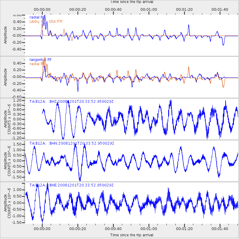
B12A Libby, MT, USA - Earthquake Result Viewer
*The percent match for this event was below the threshold and hence no stack was calculated.
| Earthquake location: |
Tonga Islands Region |
| Earthquake latitude/longitude: |
-22.9/-175.2 |
| Earthquake time(UTC): |
2008/12/01 (336) 20:21:34 GMT |
| Earthquake Depth: |
39 km |
| Earthquake Magnitude: |
5.5 MB, 5.1 MS |
| Earthquake Catalog/Contributor: |
WHDF/NEIC |
|
| Network: |
TA USArray Transportable Network (new EarthScope stations) |
| Station: |
B12A Libby, MT, USA |
| Lat/Lon: |
48.47 N/115.59 W |
| Elevation: |
764 m |
|
| Distance: |
88.8 deg |
| Az: |
35.04 deg |
| Baz: |
232.682 deg |
| Ray Param: |
$rayparam |
*The percent match for this event was below the threshold and hence was not used in the summary stack. |
|
| Radial Match: |
66.22988 % |
| Radial Bump: |
400 |
| Transverse Match: |
59.97197 % |
| Transverse Bump: |
400 |
| SOD ConfigId: |
2658 |
| Insert Time: |
2010-03-06 15:31:07.762 +0000 |
| GWidth: |
2.5 |
| Max Bumps: |
400 |
| Tol: |
0.001 |
|
Signal To Noise
| Channel | StoN | STA | LTA |
| TA:B12A: :BHN:20081201T20:33:52.950029Z | 0.539928 | 3.3783786E-7 | 6.2570905E-7 |
| TA:B12A: :BHE:20081201T20:33:52.950029Z | 2.1039615 | 9.0678725E-7 | 4.3099044E-7 |
| TA:B12A: :BHZ:20081201T20:33:52.950029Z | 0.3427227 | 2.2936418E-7 | 6.692413E-7 |
| Arrivals |
| Ps | |
| PpPs | |
| PsPs/PpSs | |


