You are here: Home > Network List > TA - USArray Transportable Network (new EarthScope stations) Stations List
> Station B12A Libby, MT, USA > Earthquake Result Viewer
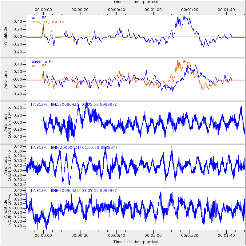
B12A Libby, MT, USA - Earthquake Result Viewer
*The percent match for this event was below the threshold and hence no stack was calculated.
| Earthquake location: |
Vanuatu Islands |
| Earthquake latitude/longitude: |
-19.8/169.9 |
| Earthquake time(UTC): |
2009/04/21 (111) 00:53:13 GMT |
| Earthquake Depth: |
36 km |
| Earthquake Magnitude: |
5.6 MB, 5.3 MS, 5.8 MW, 5.6 MW |
| Earthquake Catalog/Contributor: |
WHDF/NEIC |
|
| Network: |
TA USArray Transportable Network (new EarthScope stations) |
| Station: |
B12A Libby, MT, USA |
| Lat/Lon: |
48.47 N/115.59 W |
| Elevation: |
764 m |
|
| Distance: |
94.8 deg |
| Az: |
40.05 deg |
| Baz: |
245.581 deg |
| Ray Param: |
$rayparam |
*The percent match for this event was below the threshold and hence was not used in the summary stack. |
|
| Radial Match: |
36.23699 % |
| Radial Bump: |
400 |
| Transverse Match: |
32.0623 % |
| Transverse Bump: |
400 |
| SOD ConfigId: |
2658 |
| Insert Time: |
2010-03-06 15:31:13.326 +0000 |
| GWidth: |
2.5 |
| Max Bumps: |
400 |
| Tol: |
0.001 |
|
Signal To Noise
| Channel | StoN | STA | LTA |
| TA:B12A: :BHN:20090421T01:05:59.898997Z | 0.45155394 | 1.0792657E-7 | 2.3901146E-7 |
| TA:B12A: :BHE:20090421T01:05:59.898997Z | 2.0259998 | 3.0902234E-7 | 1.5252832E-7 |
| TA:B12A: :BHZ:20090421T01:05:59.898997Z | 0.49777803 | 1.13832506E-7 | 2.2868126E-7 |
| Arrivals |
| Ps | |
| PpPs | |
| PsPs/PpSs | |


