You are here: Home > Network List > TA - USArray Transportable Network (new EarthScope stations) Stations List
> Station 121A Cookes Peak, Deming, NM, USA > Earthquake Result Viewer
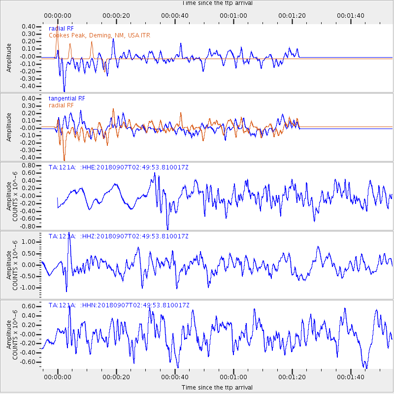
121A Cookes Peak, Deming, NM, USA - Earthquake Result Viewer
*The percent match for this event was below the threshold and hence no stack was calculated.
| Earthquake location: |
Chile-Argentina Border Region |
| Earthquake latitude/longitude: |
-28.9/-70.0 |
| Earthquake time(UTC): |
2018/09/07 (250) 02:39:17 GMT |
| Earthquake Depth: |
92 km |
| Earthquake Magnitude: |
5.8 Mww |
| Earthquake Catalog/Contributor: |
NEIC PDE/us |
|
| Network: |
TA USArray Transportable Network (new EarthScope stations) |
| Station: |
121A Cookes Peak, Deming, NM, USA |
| Lat/Lon: |
32.53 N/107.79 W |
| Elevation: |
1652 m |
|
| Distance: |
70.9 deg |
| Az: |
326.743 deg |
| Baz: |
145.299 deg |
| Ray Param: |
$rayparam |
*The percent match for this event was below the threshold and hence was not used in the summary stack. |
|
| Radial Match: |
66.52258 % |
| Radial Bump: |
400 |
| Transverse Match: |
69.099434 % |
| Transverse Bump: |
378 |
| SOD ConfigId: |
13570011 |
| Insert Time: |
2019-05-01 04:11:35.707 +0000 |
| GWidth: |
2.5 |
| Max Bumps: |
400 |
| Tol: |
0.001 |
|
Signal To Noise
| Channel | StoN | STA | LTA |
| TA:121A: :HHZ:20180907T02:49:53.810017Z | 3.0950966 | 5.630083E-7 | 1.819033E-7 |
| TA:121A: :HHN:20180907T02:49:53.810017Z | 1.421064 | 2.020351E-7 | 1.4217171E-7 |
| TA:121A: :HHE:20180907T02:49:53.810017Z | 1.701224 | 3.0952592E-7 | 1.8194308E-7 |
| Arrivals |
| Ps | |
| PpPs | |
| PsPs/PpSs | |


