You are here: Home > Network List > TA - USArray Transportable Network (new EarthScope stations) Stations List
> Station B12A Libby, MT, USA > Earthquake Result Viewer
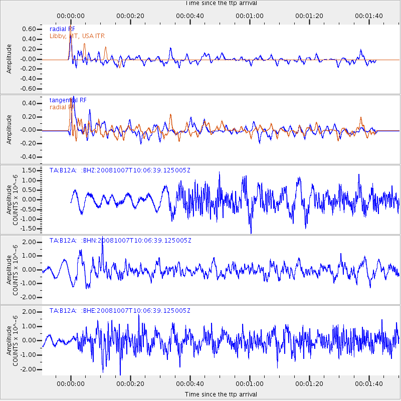
B12A Libby, MT, USA - Earthquake Result Viewer
*The percent match for this event was below the threshold and hence no stack was calculated.
| Earthquake location: |
Arctic Ocean |
| Earthquake latitude/longitude: |
79.8/-115.4 |
| Earthquake time(UTC): |
2008/10/07 (281) 10:00:48 GMT |
| Earthquake Depth: |
10 km |
| Earthquake Magnitude: |
5.6 MB, 5.5 MS, 5.7 MW, 5.7 MW |
| Earthquake Catalog/Contributor: |
WHDF/NEIC |
|
| Network: |
TA USArray Transportable Network (new EarthScope stations) |
| Station: |
B12A Libby, MT, USA |
| Lat/Lon: |
48.47 N/115.59 W |
| Elevation: |
764 m |
|
| Distance: |
31.5 deg |
| Az: |
180.18 deg |
| Baz: |
0.048 deg |
| Ray Param: |
$rayparam |
*The percent match for this event was below the threshold and hence was not used in the summary stack. |
|
| Radial Match: |
46.175266 % |
| Radial Bump: |
400 |
| Transverse Match: |
70.257545 % |
| Transverse Bump: |
400 |
| SOD ConfigId: |
2556 |
| Insert Time: |
2010-03-06 15:31:35.077 +0000 |
| GWidth: |
2.5 |
| Max Bumps: |
400 |
| Tol: |
0.001 |
|
Signal To Noise
| Channel | StoN | STA | LTA |
| TA:B12A: :BHN:20081007T10:06:39.125005Z | 4.367112 | 8.191548E-7 | 1.8757356E-7 |
| TA:B12A: :BHE:20081007T10:06:39.125005Z | 1.0915042 | 3.172955E-7 | 2.9069562E-7 |
| TA:B12A: :BHZ:20081007T10:06:39.125005Z | 2.0837145 | 5.439542E-7 | 2.6105025E-7 |
| Arrivals |
| Ps | |
| PpPs | |
| PsPs/PpSs | |


