You are here: Home > Network List > TA - USArray Transportable Network (new EarthScope stations) Stations List
> Station B12A Libby, MT, USA > Earthquake Result Viewer
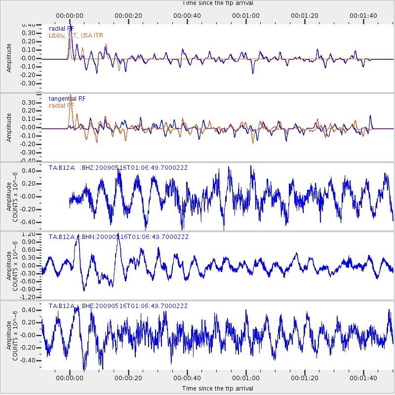
B12A Libby, MT, USA - Earthquake Result Viewer
*The percent match for this event was below the threshold and hence no stack was calculated.
| Earthquake location: |
Kermadec Islands Region |
| Earthquake latitude/longitude: |
-31.5/-178.8 |
| Earthquake time(UTC): |
2009/05/16 (136) 00:53:52 GMT |
| Earthquake Depth: |
55 km |
| Earthquake Magnitude: |
6.1 MB, 6.5 MW, 6.3 MW |
| Earthquake Catalog/Contributor: |
WHDF/NEIC |
|
| Network: |
TA USArray Transportable Network (new EarthScope stations) |
| Station: |
B12A Libby, MT, USA |
| Lat/Lon: |
48.47 N/115.59 W |
| Elevation: |
764 m |
|
| Distance: |
97.6 deg |
| Az: |
36.819 deg |
| Baz: |
230.268 deg |
| Ray Param: |
$rayparam |
*The percent match for this event was below the threshold and hence was not used in the summary stack. |
|
| Radial Match: |
70.018555 % |
| Radial Bump: |
400 |
| Transverse Match: |
44.46135 % |
| Transverse Bump: |
400 |
| SOD ConfigId: |
2760 |
| Insert Time: |
2010-03-06 15:31:43.041 +0000 |
| GWidth: |
2.5 |
| Max Bumps: |
400 |
| Tol: |
0.001 |
|
Signal To Noise
| Channel | StoN | STA | LTA |
| TA:B12A: :BHN:20090516T01:06:49.700022Z | 2.9124763 | 5.9307746E-7 | 2.036334E-7 |
| TA:B12A: :BHE:20090516T01:06:49.700022Z | 2.1361692 | 2.9639955E-7 | 1.3875282E-7 |
| TA:B12A: :BHZ:20090516T01:06:49.700022Z | 0.84203583 | 1.4172876E-7 | 1.6831679E-7 |
| Arrivals |
| Ps | |
| PpPs | |
| PsPs/PpSs | |


