You are here: Home > Network List > TA - USArray Transportable Network (new EarthScope stations) Stations List
> Station B12A Libby, MT, USA > Earthquake Result Viewer
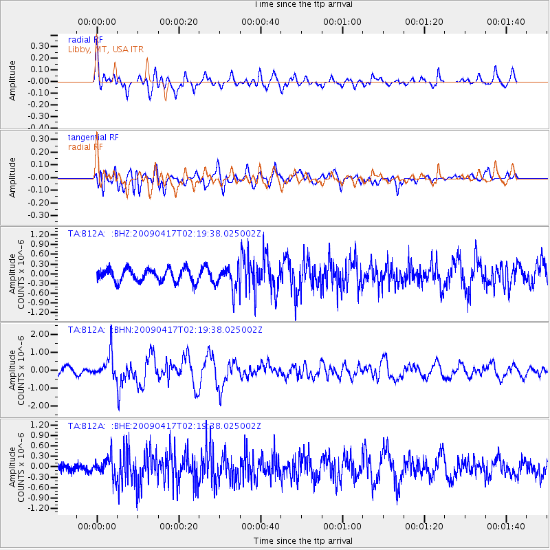
B12A Libby, MT, USA - Earthquake Result Viewer
*The percent match for this event was below the threshold and hence no stack was calculated.
| Earthquake location: |
Near Coast Of Northern Chile |
| Earthquake latitude/longitude: |
-19.6/-70.5 |
| Earthquake time(UTC): |
2009/04/17 (107) 02:08:08 GMT |
| Earthquake Depth: |
25 km |
| Earthquake Magnitude: |
5.8 MB, 5.8 MS, 6.1 MW, 6.1 MW |
| Earthquake Catalog/Contributor: |
WHDF/NEIC |
|
| Network: |
TA USArray Transportable Network (new EarthScope stations) |
| Station: |
B12A Libby, MT, USA |
| Lat/Lon: |
48.47 N/115.59 W |
| Elevation: |
764 m |
|
| Distance: |
78.8 deg |
| Az: |
331.275 deg |
| Baz: |
137.087 deg |
| Ray Param: |
$rayparam |
*The percent match for this event was below the threshold and hence was not used in the summary stack. |
|
| Radial Match: |
65.048 % |
| Radial Bump: |
400 |
| Transverse Match: |
78.59453 % |
| Transverse Bump: |
400 |
| SOD ConfigId: |
2658 |
| Insert Time: |
2010-03-06 15:31:44.931 +0000 |
| GWidth: |
2.5 |
| Max Bumps: |
400 |
| Tol: |
0.001 |
|
Signal To Noise
| Channel | StoN | STA | LTA |
| TA:B12A: :BHN:20090417T02:19:38.025002Z | 2.1735034 | 7.33448E-7 | 3.3744965E-7 |
| TA:B12A: :BHE:20090417T02:19:38.025002Z | 1.3277025 | 2.9235827E-7 | 2.2019863E-7 |
| TA:B12A: :BHZ:20090417T02:19:38.025002Z | 1.8506031 | 3.5792442E-7 | 1.934096E-7 |
| Arrivals |
| Ps | |
| PpPs | |
| PsPs/PpSs | |


