You are here: Home > Network List > TA - USArray Transportable Network (new EarthScope stations) Stations List
> Station B12A Libby, MT, USA > Earthquake Result Viewer
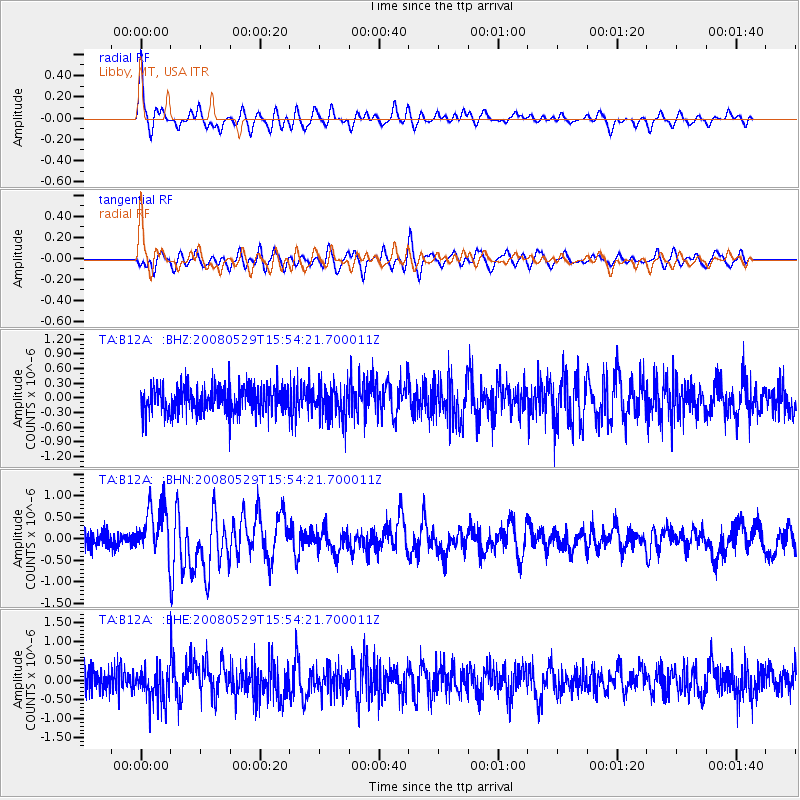
B12A Libby, MT, USA - Earthquake Result Viewer
*The percent match for this event was below the threshold and hence no stack was calculated.
| Earthquake location: |
Iceland |
| Earthquake latitude/longitude: |
64.0/-21.0 |
| Earthquake time(UTC): |
2008/05/29 (150) 15:46:00 GMT |
| Earthquake Depth: |
10 km |
| Earthquake Magnitude: |
6.0 MB, 6.2 MS, 6.3 MW, 6.2 MW |
| Earthquake Catalog/Contributor: |
WHDF/NEIC |
|
| Network: |
TA USArray Transportable Network (new EarthScope stations) |
| Station: |
B12A Libby, MT, USA |
| Lat/Lon: |
48.47 N/115.59 W |
| Elevation: |
764 m |
|
| Distance: |
49.7 deg |
| Az: |
299.583 deg |
| Baz: |
35.16 deg |
| Ray Param: |
$rayparam |
*The percent match for this event was below the threshold and hence was not used in the summary stack. |
|
| Radial Match: |
72.80139 % |
| Radial Bump: |
341 |
| Transverse Match: |
74.29565 % |
| Transverse Bump: |
353 |
| SOD ConfigId: |
2504 |
| Insert Time: |
2010-03-06 15:31:47.182 +0000 |
| GWidth: |
2.5 |
| Max Bumps: |
400 |
| Tol: |
0.001 |
|
Signal To Noise
| Channel | StoN | STA | LTA |
| TA:B12A: :BHN:20080529T15:54:21.700011Z | 3.5121126 | 5.7787236E-7 | 1.6453696E-7 |
| TA:B12A: :BHE:20080529T15:54:21.700011Z | 1.531616 | 4.4804557E-7 | 2.9253127E-7 |
| TA:B12A: :BHZ:20080529T15:54:21.700011Z | 1.2574375 | 3.3815877E-7 | 2.689269E-7 |
| Arrivals |
| Ps | |
| PpPs | |
| PsPs/PpSs | |


