You are here: Home > Network List > TA - USArray Transportable Network (new EarthScope stations) Stations List
> Station A13A Flathead National Forest, Polebridge, MT, USA > Earthquake Result Viewer
A13A Flathead National Forest, Polebridge, MT, USA - Earthquake Result Viewer
| Earthquake location: |
Sichuan, China |
| Earthquake latitude/longitude: |
32.8/105.5 |
| Earthquake time(UTC): |
2008/08/05 (218) 09:49:17 GMT |
| Earthquake Depth: |
6.0 km |
| Earthquake Magnitude: |
5.9 MB, 6.0 MS, 6.0 MW, 5.9 MW |
| Earthquake Catalog/Contributor: |
WHDF/NEIC |
|
| Network: |
TA USArray Transportable Network (new EarthScope stations) |
| Station: |
A13A Flathead National Forest, Polebridge, MT, USA |
| Lat/Lon: |
48.93 N/114.41 W |
| Elevation: |
1199 m |
|
| Distance: |
91.2 deg |
| Az: |
25.035 deg |
| Baz: |
327.268 deg |
| Ray Param: |
0.04161767 |
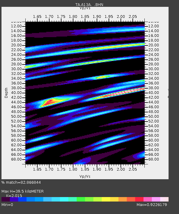
| Estimated Moho Depth: |
39.5 km |
| Estimated Crust Vp/Vs: |
2.02 |
| Assumed Crust Vp: |
6.622 km/s |
| Estimated Crust Vs: |
3.286 km/s |
| Estimated Crust Poisson's Ratio: |
0.34 |
|
| Radial Match: |
82.866844 % |
| Radial Bump: |
400 |
| Transverse Match: |
83.49449 % |
| Transverse Bump: |
400 |
| SOD ConfigId: |
2504 |
| Insert Time: |
2010-03-06 15:31:56.340 +0000 |
| GWidth: |
2.5 |
| Max Bumps: |
400 |
| Tol: |
0.001 |
|
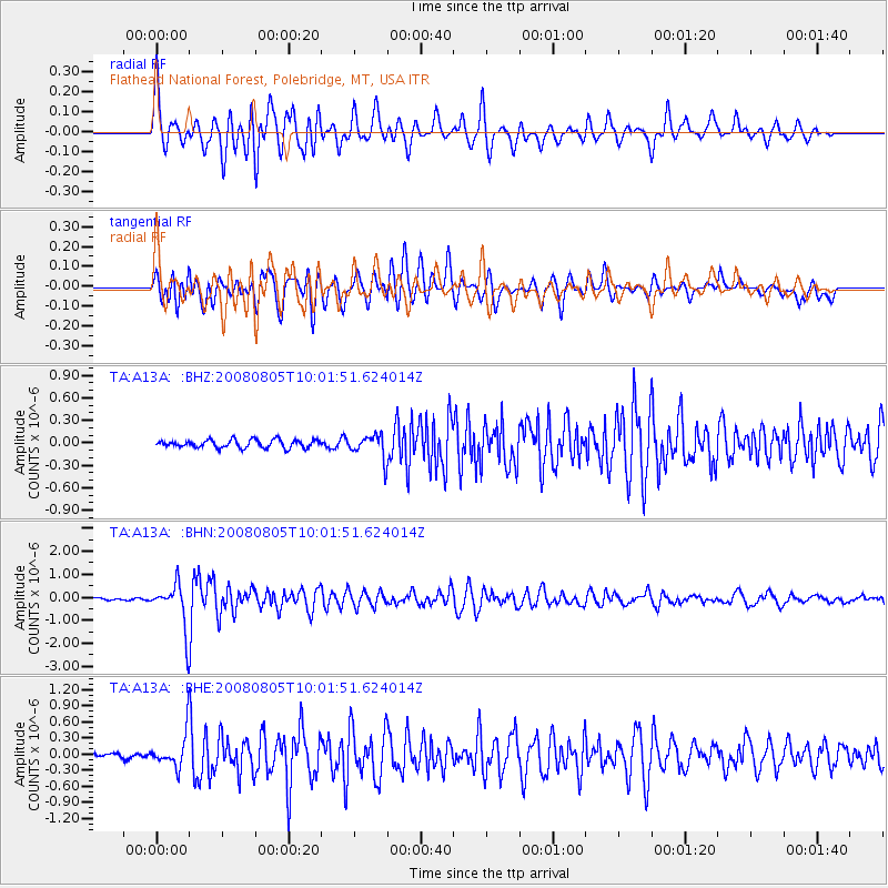
Signal To Noise
| Channel | StoN | STA | LTA |
| TA:A13A: :BHN:20080805T10:01:51.624014Z | 15.903137 | 9.698923E-7 | 6.098749E-8 |
| TA:A13A: :BHE:20080805T10:01:51.624014Z | 6.0961833 | 3.0615467E-7 | 5.0220713E-8 |
| TA:A13A: :BHZ:20080805T10:01:51.624014Z | 2.983171 | 1.595718E-7 | 5.3490663E-8 |
| Arrivals |
| Ps | 6.2 SECOND |
| PpPs | 18 SECOND |
| PsPs/PpSs | 24 SECOND |


