You are here: Home > Network List > TA - USArray Transportable Network (new EarthScope stations) Stations List
> Station A13A Flathead National Forest, Polebridge, MT, USA > Earthquake Result Viewer
A13A Flathead National Forest, Polebridge, MT, USA - Earthquake Result Viewer
| Earthquake location: |
Southwestern Ryukyu Isl., Japan |
| Earthquake latitude/longitude: |
24.2/125.1 |
| Earthquake time(UTC): |
2009/08/05 (217) 00:17:58 GMT |
| Earthquake Depth: |
25 km |
| Earthquake Magnitude: |
5.9 MB, 5.9 MS, 6.2 MW, 6.1 MW |
| Earthquake Catalog/Contributor: |
WHDF/NEIC |
|
| Network: |
TA USArray Transportable Network (new EarthScope stations) |
| Station: |
A13A Flathead National Forest, Polebridge, MT, USA |
| Lat/Lon: |
48.93 N/114.41 W |
| Elevation: |
1199 m |
|
| Distance: |
89.9 deg |
| Az: |
34.628 deg |
| Baz: |
308.126 deg |
| Ray Param: |
0.041707676 |
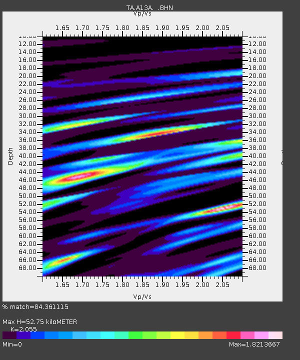
| Estimated Moho Depth: |
52.75 km |
| Estimated Crust Vp/Vs: |
2.06 |
| Assumed Crust Vp: |
6.622 km/s |
| Estimated Crust Vs: |
3.222 km/s |
| Estimated Crust Poisson's Ratio: |
0.34 |
|
| Radial Match: |
84.361115 % |
| Radial Bump: |
400 |
| Transverse Match: |
66.880066 % |
| Transverse Bump: |
400 |
| SOD ConfigId: |
2622 |
| Insert Time: |
2010-03-06 15:32:20.815 +0000 |
| GWidth: |
2.5 |
| Max Bumps: |
400 |
| Tol: |
0.001 |
|
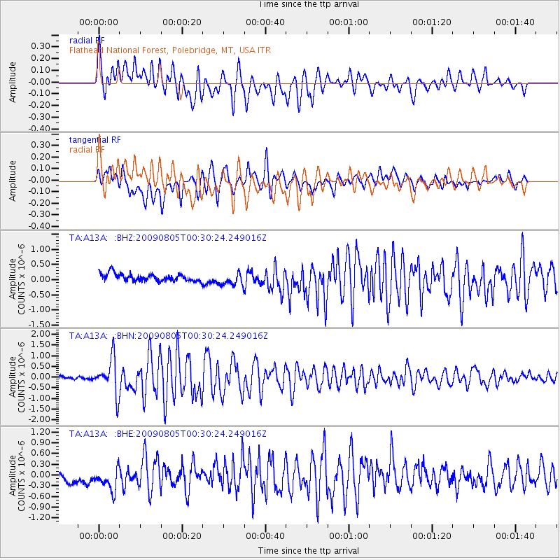
Signal To Noise
| Channel | StoN | STA | LTA |
| TA:A13A: :BHN:20090805T00:30:24.249016Z | 11.11193 | 8.588322E-7 | 7.728921E-8 |
| TA:A13A: :BHE:20090805T00:30:24.249016Z | 1.8021421 | 4.1931773E-7 | 2.3267738E-7 |
| TA:A13A: :BHZ:20090805T00:30:24.249016Z | 1.8263003 | 2.1973744E-7 | 1.2031835E-7 |
| Arrivals |
| Ps | 8.6 SECOND |
| PpPs | 24 SECOND |
| PsPs/PpSs | 32 SECOND |


