You are here: Home > Network List > TA - USArray Transportable Network (new EarthScope stations) Stations List
> Station A13A Flathead National Forest, Polebridge, MT, USA > Earthquake Result Viewer
A13A Flathead National Forest, Polebridge, MT, USA - Earthquake Result Viewer
| Earthquake location: |
North Of Honduras |
| Earthquake latitude/longitude: |
16.7/-86.2 |
| Earthquake time(UTC): |
2009/05/28 (148) 08:24:45 GMT |
| Earthquake Depth: |
10 km |
| Earthquake Magnitude: |
6.7 MB, 7.2 MS, 7.3 MW, 7.3 MW |
| Earthquake Catalog/Contributor: |
WHDF/NEIC |
|
| Network: |
TA USArray Transportable Network (new EarthScope stations) |
| Station: |
A13A Flathead National Forest, Polebridge, MT, USA |
| Lat/Lon: |
48.93 N/114.41 W |
| Elevation: |
1199 m |
|
| Distance: |
39.5 deg |
| Az: |
330.665 deg |
| Baz: |
134.611 deg |
| Ray Param: |
0.07496575 |
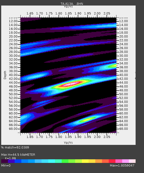
| Estimated Moho Depth: |
44.5 km |
| Estimated Crust Vp/Vs: |
1.86 |
| Assumed Crust Vp: |
6.622 km/s |
| Estimated Crust Vs: |
3.56 km/s |
| Estimated Crust Poisson's Ratio: |
0.30 |
|
| Radial Match: |
92.0389 % |
| Radial Bump: |
400 |
| Transverse Match: |
86.74926 % |
| Transverse Bump: |
400 |
| SOD ConfigId: |
2648 |
| Insert Time: |
2010-03-06 15:32:22.637 +0000 |
| GWidth: |
2.5 |
| Max Bumps: |
400 |
| Tol: |
0.001 |
|
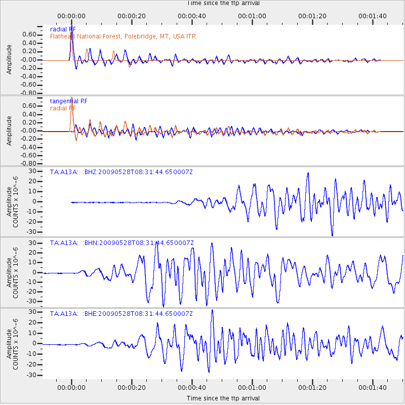
Signal To Noise
| Channel | StoN | STA | LTA |
| TA:A13A: :BHN:20090528T08:31:44.650007Z | 18.427916 | 1.2720324E-6 | 6.9027465E-8 |
| TA:A13A: :BHE:20090528T08:31:44.650007Z | 6.937067 | 5.44039E-7 | 7.842493E-8 |
| TA:A13A: :BHZ:20090528T08:31:44.650007Z | 6.5045724 | 6.164582E-7 | 9.477305E-8 |
| Arrivals |
| Ps | 6.2 SECOND |
| PpPs | 18 SECOND |
| PsPs/PpSs | 24 SECOND |


