You are here: Home > Network List > TA - USArray Transportable Network (new EarthScope stations) Stations List
> Station A13A Flathead National Forest, Polebridge, MT, USA > Earthquake Result Viewer
A13A Flathead National Forest, Polebridge, MT, USA - Earthquake Result Viewer
| Earthquake location: |
South Of Panama |
| Earthquake latitude/longitude: |
5.7/-82.8 |
| Earthquake time(UTC): |
2009/03/12 (071) 23:23:34 GMT |
| Earthquake Depth: |
9.0 km |
| Earthquake Magnitude: |
6.1 MB, 5.9 MS, 6.3 MW, 6.2 MW |
| Earthquake Catalog/Contributor: |
WHDF/NEIC |
|
| Network: |
TA USArray Transportable Network (new EarthScope stations) |
| Station: |
A13A Flathead National Forest, Polebridge, MT, USA |
| Lat/Lon: |
48.93 N/114.41 W |
| Elevation: |
1199 m |
|
| Distance: |
50.8 deg |
| Az: |
333.463 deg |
| Baz: |
137.608 deg |
| Ray Param: |
0.067846075 |
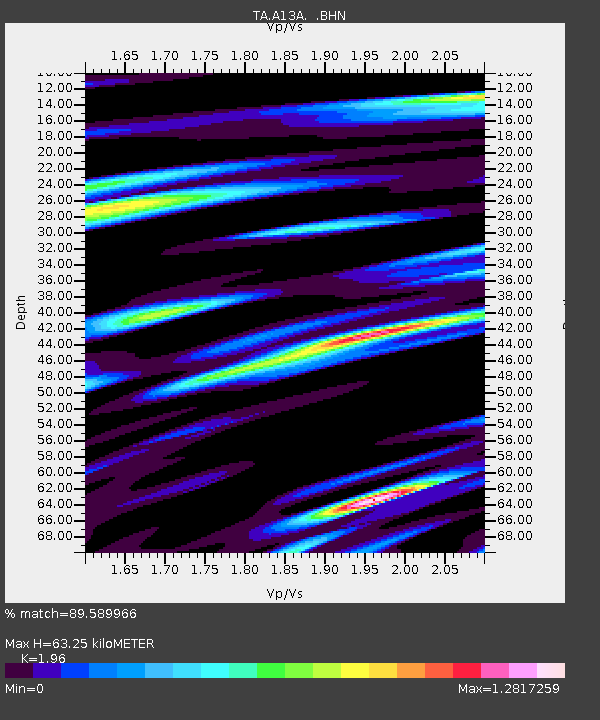
| Estimated Moho Depth: |
63.25 km |
| Estimated Crust Vp/Vs: |
1.96 |
| Assumed Crust Vp: |
6.622 km/s |
| Estimated Crust Vs: |
3.379 km/s |
| Estimated Crust Poisson's Ratio: |
0.32 |
|
| Radial Match: |
89.589966 % |
| Radial Bump: |
400 |
| Transverse Match: |
65.407776 % |
| Transverse Bump: |
400 |
| SOD ConfigId: |
2658 |
| Insert Time: |
2010-03-06 15:32:26.893 +0000 |
| GWidth: |
2.5 |
| Max Bumps: |
400 |
| Tol: |
0.001 |
|
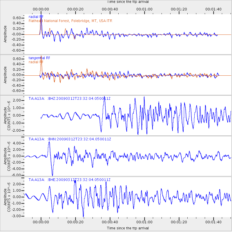
Signal To Noise
| Channel | StoN | STA | LTA |
| TA:A13A: :BHN:20090312T23:32:04.050011Z | 12.233452 | 1.5782317E-6 | 1.2900952E-7 |
| TA:A13A: :BHE:20090312T23:32:04.050011Z | 2.6080282 | 5.382635E-7 | 2.0638717E-7 |
| TA:A13A: :BHZ:20090312T23:32:04.050011Z | 2.3403316 | 5.723719E-7 | 2.4456872E-7 |
| Arrivals |
| Ps | 9.7 SECOND |
| PpPs | 27 SECOND |
| PsPs/PpSs | 36 SECOND |


