You are here: Home > Network List > TA - USArray Transportable Network (new EarthScope stations) Stations List
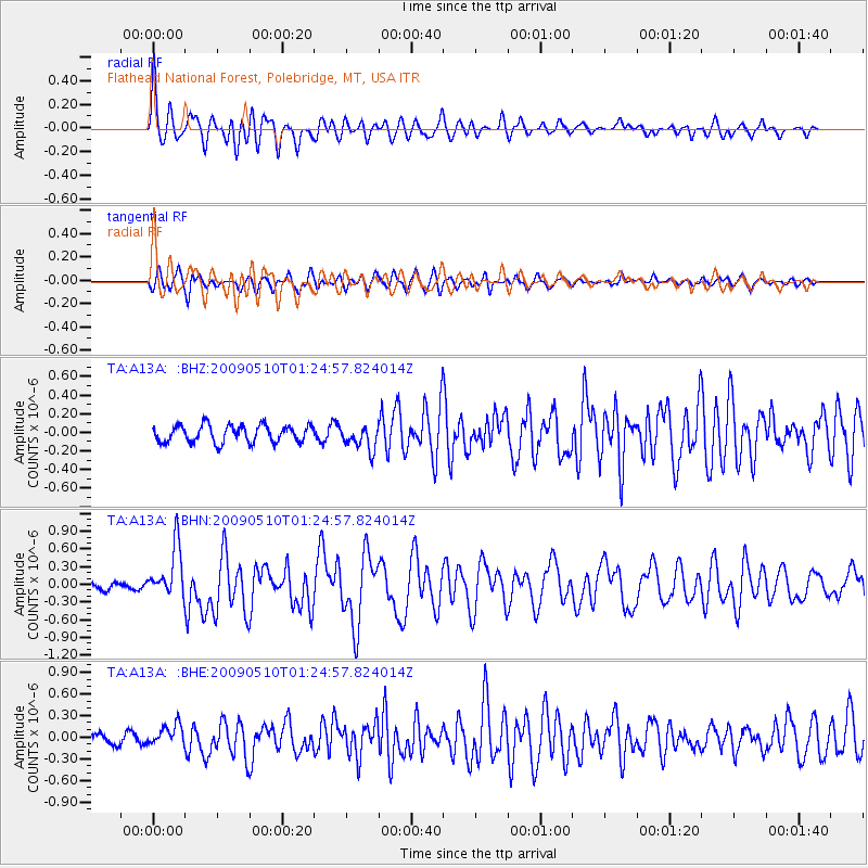
> Station A13A Flathead National Forest, Polebridge, MT, USA > Earthquake Result Viewer
A13A Flathead National Forest, Polebridge, MT, USA - Earthquake Result Viewer
| Earthquake location: |
Off Coast Of Ecuador |
| Earthquake latitude/longitude: |
1.4/-85.2 |
| Earthquake time(UTC): |
2009/05/10 (130) 01:16:06 GMT |
| Earthquake Depth: |
6.0 km |
| Earthquake Magnitude: |
5.5 MB, 5.7 MS, 6.1 MW, 6.1 MW |
| Earthquake Catalog/Contributor: |
WHDF/NEIC |
|
| Network: |
TA USArray Transportable Network (new EarthScope stations) |
| Station: |
A13A Flathead National Forest, Polebridge, MT, USA |
| Lat/Lon: |
48.93 N/114.41 W |
| Elevation: |
1199 m |
|
| Distance: |
53.6 deg |
| Az: |
336.407 deg |
| Baz: |
142.644 deg |
| Ray Param: |
0.06599958 |
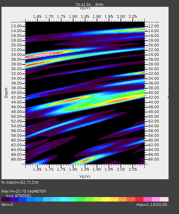
| Estimated Moho Depth: |
23.75 km |
| Estimated Crust Vp/Vs: |
1.68 |
| Assumed Crust Vp: |
6.622 km/s |
| Estimated Crust Vs: |
3.954 km/s |
| Estimated Crust Poisson's Ratio: |
0.22 |
|
| Radial Match: |
82.71234 % |
| Radial Bump: |
400 |
| Transverse Match: |
68.961006 % |
| Transverse Bump: |
400 |
| SOD ConfigId: |
2760 |
| Insert Time: |
2010-03-06 15:32:49.786 +0000 |
| GWidth: |
2.5 |
| Max Bumps: |
400 |
| Tol: |
0.001 |
|
Signal To Noise
| Channel | StoN | STA | LTA |
| TA:A13A: :BHN:20090510T01:24:57.824014Z | 3.3332634 | 4.4150153E-7 | 1.3245324E-7 |
| TA:A13A: :BHE:20090510T01:24:57.824014Z | 1.8214434 | 1.4693647E-7 | 8.067035E-8 |
| TA:A13A: :BHZ:20090510T01:24:57.824014Z | 1.4363757 | 1.3141323E-7 | 9.1489454E-8 |
| Arrivals |
| Ps | 2.6 SECOND |
| PpPs | 9.0 SECOND |
| PsPs/PpSs | 12 SECOND |


