You are here: Home > Network List > AK - Alaska Regional Network Stations List
> Station NICH Nichawak Mountain, AK, USA > Earthquake Result Viewer
NICH Nichawak Mountain, AK, USA - Earthquake Result Viewer
| Earthquake location: |
Mindanao, Philippines |
| Earthquake latitude/longitude: |
7.2/126.5 |
| Earthquake time(UTC): |
2018/09/08 (251) 07:16:49 GMT |
| Earthquake Depth: |
10 km |
| Earthquake Magnitude: |
6.1 Mww |
| Earthquake Catalog/Contributor: |
NEIC PDE/us |
|
| Network: |
AK Alaska Regional Network |
| Station: |
NICH Nichawak Mountain, AK, USA |
| Lat/Lon: |
60.24 N/143.97 W |
| Elevation: |
507 m |
|
| Distance: |
83.6 deg |
| Az: |
30.139 deg |
| Baz: |
273.231 deg |
| Ray Param: |
0.04610389 |
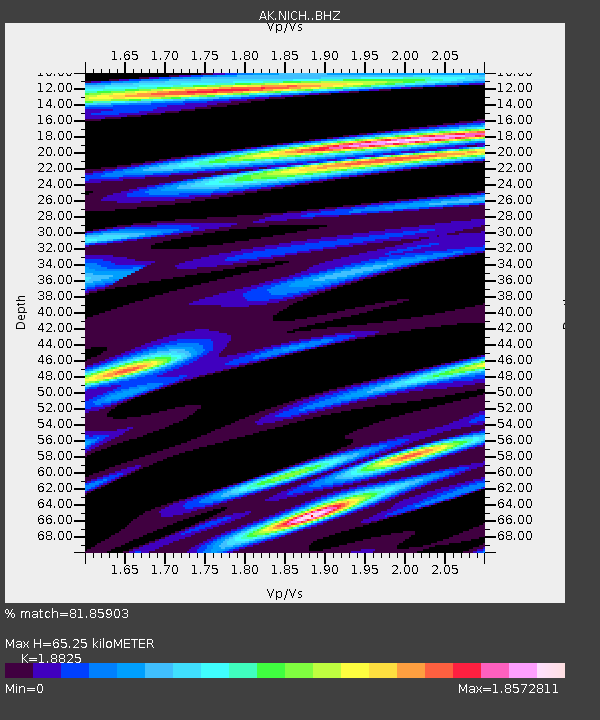
| Estimated Moho Depth: |
65.25 km |
| Estimated Crust Vp/Vs: |
1.88 |
| Assumed Crust Vp: |
6.566 km/s |
| Estimated Crust Vs: |
3.488 km/s |
| Estimated Crust Poisson's Ratio: |
0.30 |
|
| Radial Match: |
81.85903 % |
| Radial Bump: |
400 |
| Transverse Match: |
82.18981 % |
| Transverse Bump: |
400 |
| SOD ConfigId: |
13570011 |
| Insert Time: |
2019-05-01 04:25:08.500 +0000 |
| GWidth: |
2.5 |
| Max Bumps: |
400 |
| Tol: |
0.001 |
|

Signal To Noise
| Channel | StoN | STA | LTA |
| AK:NICH: :BHZ:20180908T07:28:46.288027Z | 2.8553154 | 2.7817697E-7 | 9.742424E-8 |
| AK:NICH: :BHN:20180908T07:28:46.288027Z | 1.5937192 | 1.6487398E-7 | 1.0345234E-7 |
| AK:NICH: :BHE:20180908T07:28:46.288027Z | 1.2592787 | 1.4651967E-7 | 1.1635207E-7 |
| Arrivals |
| Ps | 9.0 SECOND |
| PpPs | 28 SECOND |
| PsPs/PpSs | 37 SECOND |


