You are here: Home > Network List > TA - USArray Transportable Network (new EarthScope stations) Stations List
> Station A13A Flathead National Forest, Polebridge, MT, USA > Earthquake Result Viewer
A13A Flathead National Forest, Polebridge, MT, USA - Earthquake Result Viewer
| Earthquake location: |
Near Coast Of Peru |
| Earthquake latitude/longitude: |
-13.6/-76.6 |
| Earthquake time(UTC): |
2007/08/19 (231) 01:22:40 GMT |
| Earthquake Depth: |
26 km |
| Earthquake Magnitude: |
5.9 MB, 5.4 MS, 5.8 MW, 5.5 ML |
| Earthquake Catalog/Contributor: |
WHDF/NEIC |
|
| Network: |
TA USArray Transportable Network (new EarthScope stations) |
| Station: |
A13A Flathead National Forest, Polebridge, MT, USA |
| Lat/Lon: |
48.93 N/114.41 W |
| Elevation: |
1199 m |
|
| Distance: |
70.7 deg |
| Az: |
334.644 deg |
| Baz: |
140.851 deg |
| Ray Param: |
0.054778602 |
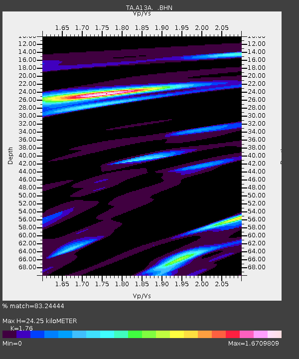
| Estimated Moho Depth: |
24.25 km |
| Estimated Crust Vp/Vs: |
1.76 |
| Assumed Crust Vp: |
6.622 km/s |
| Estimated Crust Vs: |
3.763 km/s |
| Estimated Crust Poisson's Ratio: |
0.26 |
|
| Radial Match: |
83.24444 % |
| Radial Bump: |
400 |
| Transverse Match: |
79.35641 % |
| Transverse Bump: |
400 |
| SOD ConfigId: |
2564 |
| Insert Time: |
2010-03-06 15:33:08.166 +0000 |
| GWidth: |
2.5 |
| Max Bumps: |
400 |
| Tol: |
0.001 |
|
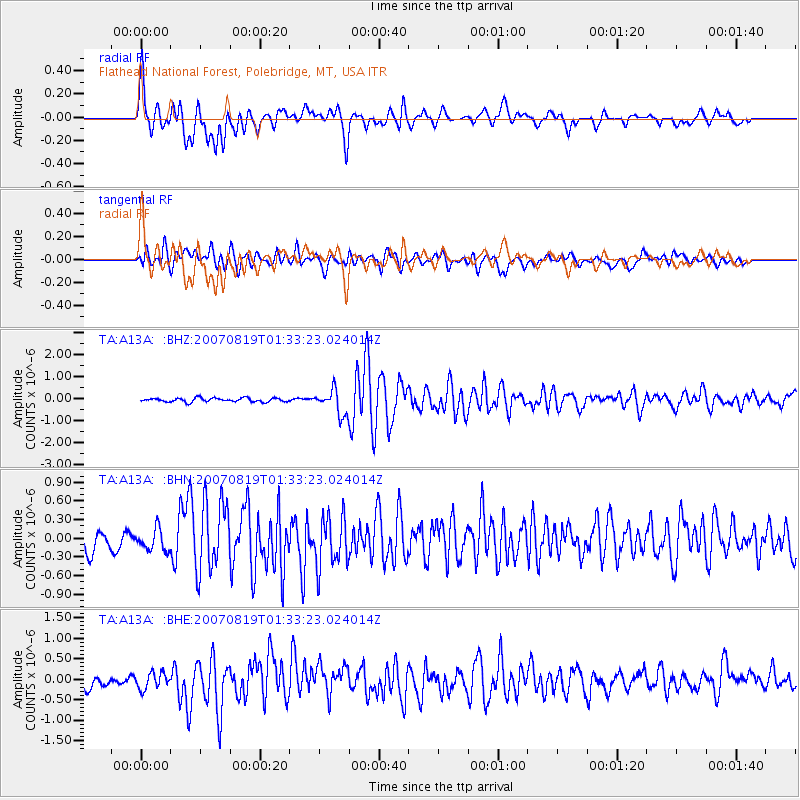
Signal To Noise
| Channel | StoN | STA | LTA |
| TA:A13A: :BHN:20070819T01:33:23.024014Z | 1.245721 | 1.7484535E-7 | 1.4035675E-7 |
| TA:A13A: :BHE:20070819T01:33:23.024014Z | 1.5349998 | 1.9509562E-7 | 1.2709815E-7 |
| TA:A13A: :BHZ:20070819T01:33:23.024014Z | 6.380246 | 5.5428586E-7 | 8.687531E-8 |
| Arrivals |
| Ps | 2.9 SECOND |
| PpPs | 9.7 SECOND |
| PsPs/PpSs | 13 SECOND |


