You are here: Home > Network List > TA - USArray Transportable Network (new EarthScope stations) Stations List
> Station A13A Flathead National Forest, Polebridge, MT, USA > Earthquake Result Viewer
A13A Flathead National Forest, Polebridge, MT, USA - Earthquake Result Viewer
| Earthquake location: |
Western Brazil |
| Earthquake latitude/longitude: |
-8.1/-71.3 |
| Earthquake time(UTC): |
2007/07/21 (202) 13:27:04 GMT |
| Earthquake Depth: |
645 km |
| Earthquake Magnitude: |
6.2 MB, 6.1 MW, 6.0 MW |
| Earthquake Catalog/Contributor: |
WHDF/NEIC |
|
| Network: |
TA USArray Transportable Network (new EarthScope stations) |
| Station: |
A13A Flathead National Forest, Polebridge, MT, USA |
| Lat/Lon: |
48.93 N/114.41 W |
| Elevation: |
1199 m |
|
| Distance: |
68.2 deg |
| Az: |
330.953 deg |
| Baz: |
133.2 deg |
| Ray Param: |
0.05407468 |
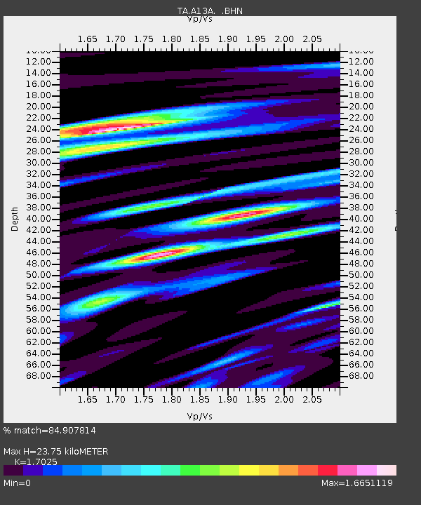
| Estimated Moho Depth: |
23.75 km |
| Estimated Crust Vp/Vs: |
1.70 |
| Assumed Crust Vp: |
6.622 km/s |
| Estimated Crust Vs: |
3.89 km/s |
| Estimated Crust Poisson's Ratio: |
0.24 |
|
| Radial Match: |
84.907814 % |
| Radial Bump: |
400 |
| Transverse Match: |
79.5291 % |
| Transverse Bump: |
400 |
| SOD ConfigId: |
2564 |
| Insert Time: |
2010-03-06 15:33:21.853 +0000 |
| GWidth: |
2.5 |
| Max Bumps: |
400 |
| Tol: |
0.001 |
|
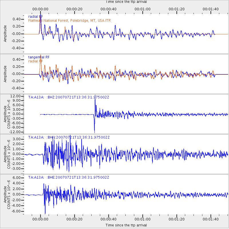
Signal To Noise
| Channel | StoN | STA | LTA |
| TA:A13A: :BHN:20070721T13:36:31.975002Z | 14.198111 | 9.469695E-7 | 6.669687E-8 |
| TA:A13A: :BHE:20070721T13:36:31.975002Z | 29.439262 | 1.875546E-6 | 6.3709E-8 |
| TA:A13A: :BHZ:20070721T13:36:31.975002Z | 68.277115 | 3.4404638E-6 | 5.038971E-8 |
| Arrivals |
| Ps | 2.6 SECOND |
| PpPs | 9.3 SECOND |
| PsPs/PpSs | 12 SECOND |


