You are here: Home > Network List > TA - USArray Transportable Network (new EarthScope stations) Stations List
> Station A13A Flathead National Forest, Polebridge, MT, USA > Earthquake Result Viewer
A13A Flathead National Forest, Polebridge, MT, USA - Earthquake Result Viewer
| Earthquake location: |
Fox Islands, Aleutian Islands |
| Earthquake latitude/longitude: |
52.5/-168.0 |
| Earthquake time(UTC): |
2007/07/15 (196) 13:08:00 GMT |
| Earthquake Depth: |
10 km |
| Earthquake Magnitude: |
5.8 MB, 5.9 MS, 6.1 MW, 6.0 MW |
| Earthquake Catalog/Contributor: |
WHDF/NEIC |
|
| Network: |
TA USArray Transportable Network (new EarthScope stations) |
| Station: |
A13A Flathead National Forest, Polebridge, MT, USA |
| Lat/Lon: |
48.93 N/114.41 W |
| Elevation: |
1199 m |
|
| Distance: |
33.5 deg |
| Az: |
74.183 deg |
| Baz: |
296.828 deg |
| Ray Param: |
0.07817981 |
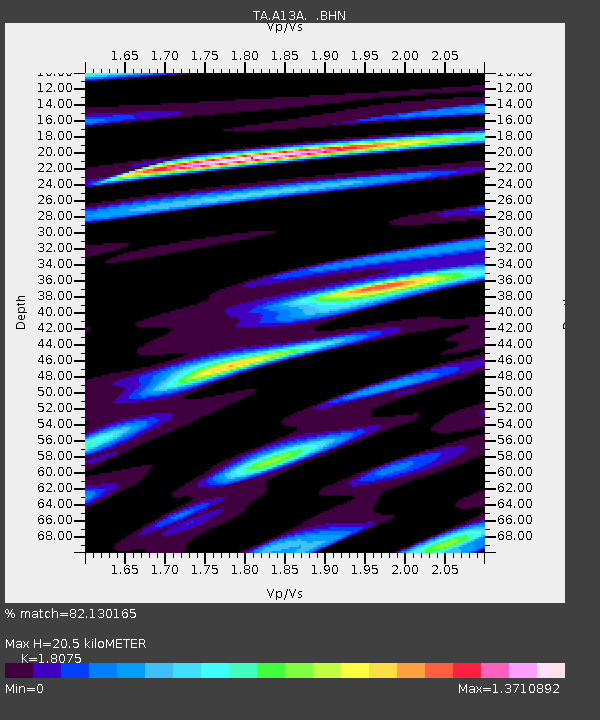
| Estimated Moho Depth: |
20.5 km |
| Estimated Crust Vp/Vs: |
1.81 |
| Assumed Crust Vp: |
6.622 km/s |
| Estimated Crust Vs: |
3.664 km/s |
| Estimated Crust Poisson's Ratio: |
0.28 |
|
| Radial Match: |
82.130165 % |
| Radial Bump: |
400 |
| Transverse Match: |
69.67701 % |
| Transverse Bump: |
400 |
| SOD ConfigId: |
2564 |
| Insert Time: |
2010-03-06 15:33:27.793 +0000 |
| GWidth: |
2.5 |
| Max Bumps: |
400 |
| Tol: |
0.001 |
|
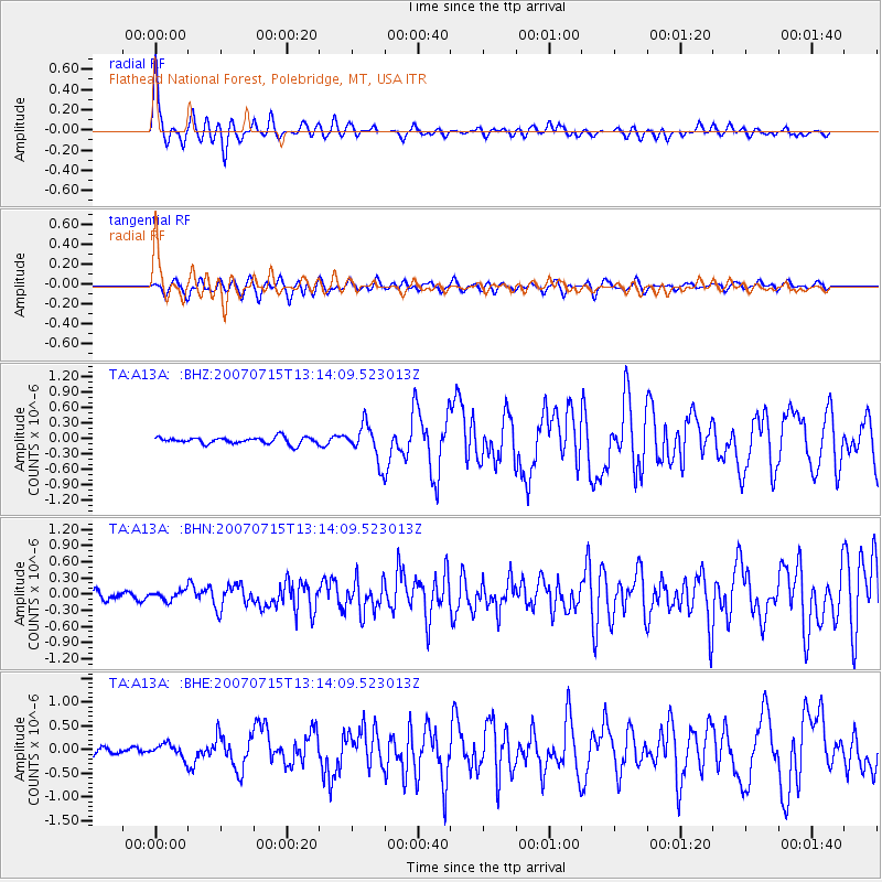
Signal To Noise
| Channel | StoN | STA | LTA |
| TA:A13A: :BHN:20070715T13:14:09.523013Z | 1.0157996 | 8.344041E-8 | 8.214259E-8 |
| TA:A13A: :BHE:20070715T13:14:09.523013Z | 1.7941592 | 1.4070092E-7 | 7.842164E-8 |
| TA:A13A: :BHZ:20070715T13:14:09.523013Z | 5.429952 | 3.4838516E-7 | 6.41599E-8 |
| Arrivals |
| Ps | 2.7 SECOND |
| PpPs | 8.0 SECOND |
| PsPs/PpSs | 11 SECOND |


