You are here: Home > Network List > TA - USArray Transportable Network (new EarthScope stations) Stations List
> Station A13A Flathead National Forest, Polebridge, MT, USA > Earthquake Result Viewer
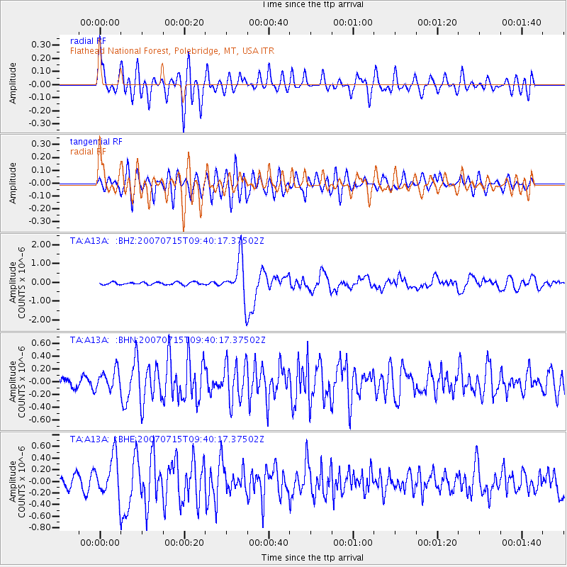
A13A Flathead National Forest, Polebridge, MT, USA - Earthquake Result Viewer

| Earthquake location: |
Vanuatu Islands |
| Earthquake latitude/longitude: |
-15.4/168.6 |
| Earthquake time(UTC): |
2007/07/15 (196) 09:27:34 GMT |
| Earthquake Depth: |
8.0 km |
| Earthquake Magnitude: |
6.0 MB, 5.8 MS, 6.1 MW, 6.0 MW |
| Earthquake Catalog/Contributor: |
WHDF/NEIC |
|
| Network: |
TA USArray Transportable Network (new EarthScope stations) |
| Station: |
A13A Flathead National Forest, Polebridge, MT, USA |
| Lat/Lon: |
48.93 N/114.41 W |
| Elevation: |
1199 m |
|
| Distance: |
93.2 deg |
| Az: |
40.053 deg |
| Baz: |
250.269 deg |
| Ray Param: |
0.041318383 |
| Estimated Moho Depth: |
32.5 km |
| Estimated Crust Vp/Vs: |
2.05 |
| Assumed Crust Vp: |
6.622 km/s |
| Estimated Crust Vs: |
3.226 km/s |
| Estimated Crust Poisson's Ratio: |
0.34 |
|
| Radial Match: |
81.97501 % |
| Radial Bump: |
400 |
| Transverse Match: |
75.8841 % |
| Transverse Bump: |
400 |
| SOD ConfigId: |
2564 |
| Insert Time: |
2010-03-06 15:33:29.455 +0000 |
| GWidth: |
2.5 |
| Max Bumps: |
400 |
| Tol: |
0.001 |
|
Signal To Noise
| Channel | StoN | STA | LTA |
| TA:A13A: :BHN:20070715T09:40:17.37502Z | 1.9434588 | 1.5869232E-7 | 8.1654576E-8 |
| TA:A13A: :BHE:20070715T09:40:17.37502Z | 4.7129927 | 3.5303654E-7 | 7.4907085E-8 |
| TA:A13A: :BHZ:20070715T09:40:17.37502Z | 16.835157 | 1.1115974E-6 | 6.6028335E-8 |
| Arrivals |
| Ps | 5.3 SECOND |
| PpPs | 15 SECOND |
| PsPs/PpSs | 20 SECOND |


