You are here: Home > Network List > TA - USArray Transportable Network (new EarthScope stations) Stations List
> Station A13A Flathead National Forest, Polebridge, MT, USA > Earthquake Result Viewer
A13A Flathead National Forest, Polebridge, MT, USA - Earthquake Result Viewer
| Earthquake location: |
Central Mid-Atlantic Ridge |
| Earthquake latitude/longitude: |
0.7/-30.3 |
| Earthquake time(UTC): |
2007/07/03 (184) 08:26:00 GMT |
| Earthquake Depth: |
10 km |
| Earthquake Magnitude: |
5.8 MB, 5.9 MS, 6.3 MW, 6.1 MW |
| Earthquake Catalog/Contributor: |
WHDF/NEIC |
|
| Network: |
TA USArray Transportable Network (new EarthScope stations) |
| Station: |
A13A Flathead National Forest, Polebridge, MT, USA |
| Lat/Lon: |
48.93 N/114.41 W |
| Elevation: |
1199 m |
|
| Distance: |
85.6 deg |
| Az: |
318.857 deg |
| Baz: |
93.942 deg |
| Ray Param: |
0.04464422 |
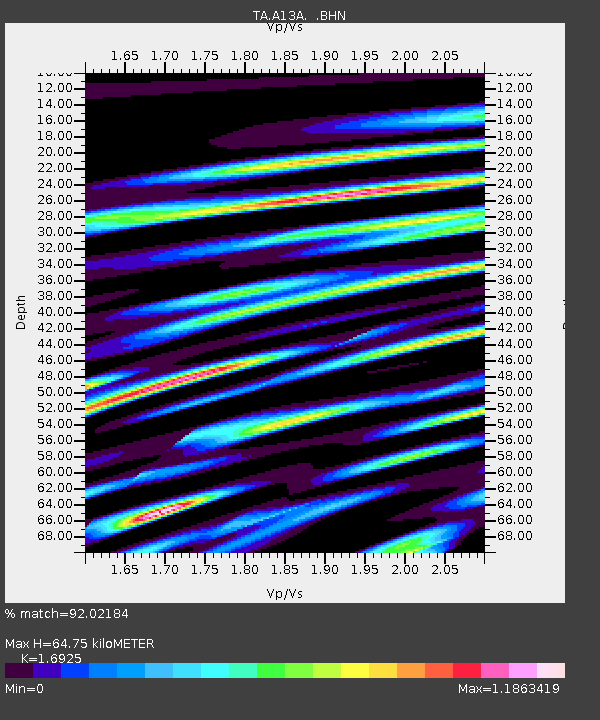
| Estimated Moho Depth: |
64.75 km |
| Estimated Crust Vp/Vs: |
1.69 |
| Assumed Crust Vp: |
6.622 km/s |
| Estimated Crust Vs: |
3.913 km/s |
| Estimated Crust Poisson's Ratio: |
0.23 |
|
| Radial Match: |
92.02184 % |
| Radial Bump: |
400 |
| Transverse Match: |
88.57203 % |
| Transverse Bump: |
400 |
| SOD ConfigId: |
2564 |
| Insert Time: |
2010-03-06 15:33:31.075 +0000 |
| GWidth: |
2.5 |
| Max Bumps: |
400 |
| Tol: |
0.001 |
|
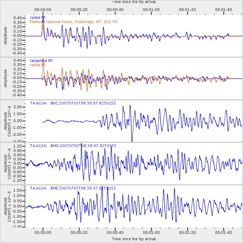
Signal To Noise
| Channel | StoN | STA | LTA |
| TA:A13A: :BHN:20070703T08:38:07.825015Z | 0.9645661 | 8.433611E-8 | 8.7434245E-8 |
| TA:A13A: :BHE:20070703T08:38:07.825015Z | 1.6861459 | 1.5351789E-7 | 9.104662E-8 |
| TA:A13A: :BHZ:20070703T08:38:07.825015Z | 3.7992458 | 3.6467955E-7 | 9.598735E-8 |
| Arrivals |
| Ps | 7.0 SECOND |
| PpPs | 26 SECOND |
| PsPs/PpSs | 33 SECOND |


