You are here: Home > Network List > JP - Japan Meteorological Agency Seismic Network Stations List
> Station JGF Gifu Kurokawa > Earthquake Result Viewer
JGF Gifu Kurokawa - Earthquake Result Viewer
| Earthquake location: |
Mindanao, Philippines |
| Earthquake latitude/longitude: |
7.2/126.5 |
| Earthquake time(UTC): |
2018/09/08 (251) 07:16:49 GMT |
| Earthquake Depth: |
10 km |
| Earthquake Magnitude: |
6.1 Mww |
| Earthquake Catalog/Contributor: |
NEIC PDE/us |
|
| Network: |
JP Japan Meteorological Agency Seismic Network |
| Station: |
JGF Gifu Kurokawa |
| Lat/Lon: |
35.60 N/137.35 E |
| Elevation: |
580 m |
|
| Distance: |
29.9 deg |
| Az: |
17.968 deg |
| Baz: |
202.06 deg |
| Ray Param: |
0.079461165 |
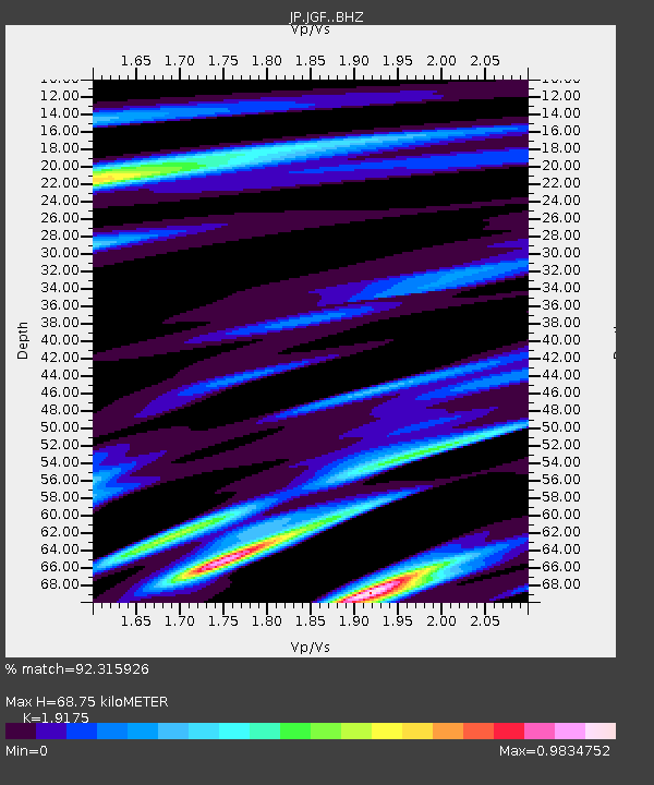
| Estimated Moho Depth: |
68.75 km |
| Estimated Crust Vp/Vs: |
1.92 |
| Assumed Crust Vp: |
6.461 km/s |
| Estimated Crust Vs: |
3.37 km/s |
| Estimated Crust Poisson's Ratio: |
0.31 |
|
| Radial Match: |
92.315926 % |
| Radial Bump: |
384 |
| Transverse Match: |
74.43307 % |
| Transverse Bump: |
400 |
| SOD ConfigId: |
13570011 |
| Insert Time: |
2019-05-01 04:27:05.071 +0000 |
| GWidth: |
2.5 |
| Max Bumps: |
400 |
| Tol: |
0.001 |
|

Signal To Noise
| Channel | StoN | STA | LTA |
| JP:JGF: :BHZ:20180908T07:22:27.200015Z | 5.363624 | 6.842885E-7 | 1.2757951E-7 |
| JP:JGF: :BHN:20180908T07:22:27.200015Z | 3.6586928 | 3.5517493E-7 | 9.7077006E-8 |
| JP:JGF: :BHE:20180908T07:22:27.200015Z | 2.5707934 | 2.6726457E-7 | 1.03961895E-7 |
| Arrivals |
| Ps | 11 SECOND |
| PpPs | 29 SECOND |
| PsPs/PpSs | 39 SECOND |


