You are here: Home > Network List > TA - USArray Transportable Network (new EarthScope stations) Stations List
> Station A13A Flathead National Forest, Polebridge, MT, USA > Earthquake Result Viewer
A13A Flathead National Forest, Polebridge, MT, USA - Earthquake Result Viewer
| Earthquake location: |
Loyalty Islands |
| Earthquake latitude/longitude: |
-20.1/168.9 |
| Earthquake time(UTC): |
2008/04/09 (100) 12:46:12 GMT |
| Earthquake Depth: |
33 km |
| Earthquake Magnitude: |
6.3 MB, 7.3 MS, 7.3 MW, 7.3 MW |
| Earthquake Catalog/Contributor: |
WHDF/NEIC |
|
| Network: |
TA USArray Transportable Network (new EarthScope stations) |
| Station: |
A13A Flathead National Forest, Polebridge, MT, USA |
| Lat/Lon: |
48.93 N/114.41 W |
| Elevation: |
1199 m |
|
| Distance: |
96.5 deg |
| Az: |
40.236 deg |
| Baz: |
247.037 deg |
| Ray Param: |
0.04047045 |
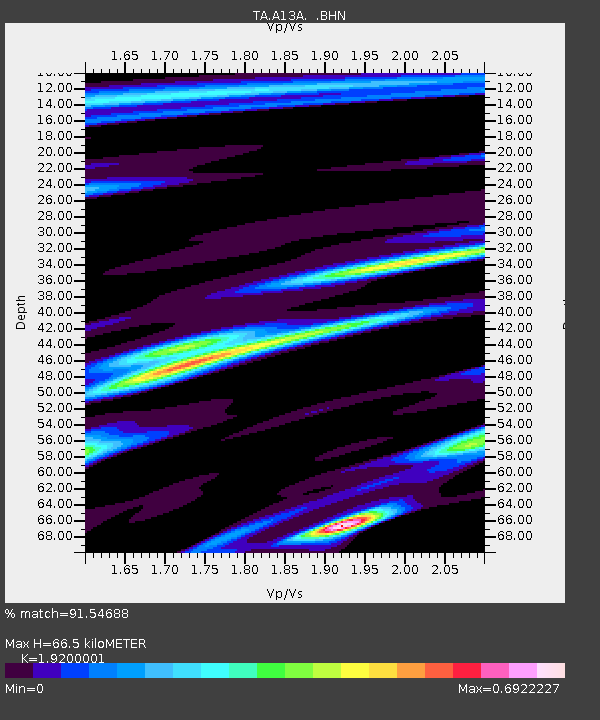
| Estimated Moho Depth: |
66.5 km |
| Estimated Crust Vp/Vs: |
1.92 |
| Assumed Crust Vp: |
6.622 km/s |
| Estimated Crust Vs: |
3.449 km/s |
| Estimated Crust Poisson's Ratio: |
0.31 |
|
| Radial Match: |
91.54688 % |
| Radial Bump: |
373 |
| Transverse Match: |
83.72543 % |
| Transverse Bump: |
400 |
| SOD ConfigId: |
2504 |
| Insert Time: |
2010-03-06 15:33:39.633 +0000 |
| GWidth: |
2.5 |
| Max Bumps: |
400 |
| Tol: |
0.001 |
|

Signal To Noise
| Channel | StoN | STA | LTA |
| TA:A13A: :BHN:20080409T12:59:07.475005Z | 2.4693234 | 1.1644435E-6 | 4.715638E-7 |
| TA:A13A: :BHE:20080409T12:59:07.475005Z | 1.5734558 | 2.1115946E-7 | 1.3420107E-7 |
| TA:A13A: :BHZ:20080409T12:59:07.475005Z | 3.78991 | 5.372208E-7 | 1.4175028E-7 |
| Arrivals |
| Ps | 9.4 SECOND |
| PpPs | 29 SECOND |
| PsPs/PpSs | 38 SECOND |


