You are here: Home > Network List > TA - USArray Transportable Network (new EarthScope stations) Stations List
> Station A13A Flathead National Forest, Polebridge, MT, USA > Earthquake Result Viewer
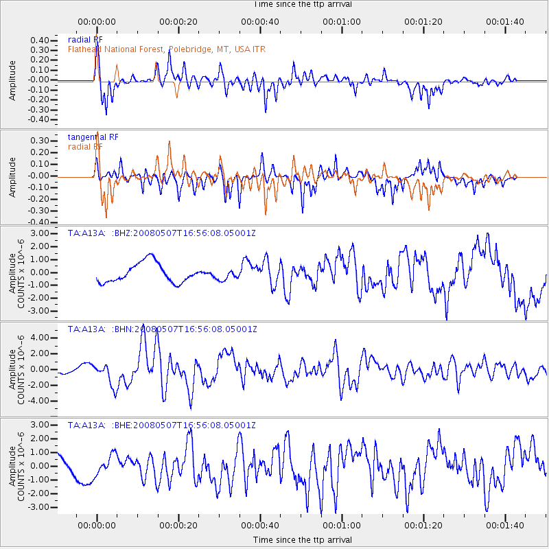
A13A Flathead National Forest, Polebridge, MT, USA - Earthquake Result Viewer
| Earthquake location: |
Near East Coast Of Honshu, Japan |
| Earthquake latitude/longitude: |
36.2/141.5 |
| Earthquake time(UTC): |
2008/05/07 (128) 16:45:20 GMT |
| Earthquake Depth: |
39 km |
| Earthquake Magnitude: |
6.1 MB, 6.7 MS, 6.8 MW, 6.8 MW |
| Earthquake Catalog/Contributor: |
WHDF/NEIC |
|
| Network: |
TA USArray Transportable Network (new EarthScope stations) |
| Station: |
A13A Flathead National Forest, Polebridge, MT, USA |
| Lat/Lon: |
48.93 N/114.41 W |
| Elevation: |
1199 m |
|
| Distance: |
71.8 deg |
| Az: |
42.319 deg |
| Baz: |
304.287 deg |
| Ray Param: |
0.0540028 |
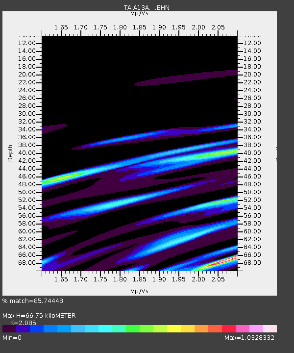
| Estimated Moho Depth: |
66.75 km |
| Estimated Crust Vp/Vs: |
2.09 |
| Assumed Crust Vp: |
6.622 km/s |
| Estimated Crust Vs: |
3.176 km/s |
| Estimated Crust Poisson's Ratio: |
0.35 |
|
| Radial Match: |
85.74448 % |
| Radial Bump: |
400 |
| Transverse Match: |
89.156944 % |
| Transverse Bump: |
385 |
| SOD ConfigId: |
2504 |
| Insert Time: |
2010-03-06 15:33:43.628 +0000 |
| GWidth: |
2.5 |
| Max Bumps: |
400 |
| Tol: |
0.001 |
|
Signal To Noise
| Channel | StoN | STA | LTA |
| TA:A13A: :BHN:20080507T16:56:08.05001Z | 2.742531 | 1.4818032E-6 | 5.4030494E-7 |
| TA:A13A: :BHE:20080507T16:56:08.05001Z | 1.0722263 | 7.170476E-7 | 6.687465E-7 |
| TA:A13A: :BHZ:20080507T16:56:08.05001Z | 0.54954934 | 4.116066E-7 | 7.4898935E-7 |
| Arrivals |
| Ps | 11 SECOND |
| PpPs | 30 SECOND |
| PsPs/PpSs | 41 SECOND |


