You are here: Home > Network List > TA - USArray Transportable Network (new EarthScope stations) Stations List
> Station E19K Redstone River, AK, USA > Earthquake Result Viewer
E19K Redstone River, AK, USA - Earthquake Result Viewer
| Earthquake location: |
Mindanao, Philippines |
| Earthquake latitude/longitude: |
7.2/126.5 |
| Earthquake time(UTC): |
2018/09/08 (251) 07:16:49 GMT |
| Earthquake Depth: |
10 km |
| Earthquake Magnitude: |
6.1 Mww |
| Earthquake Catalog/Contributor: |
NEIC PDE/us |
|
| Network: |
TA USArray Transportable Network (new EarthScope stations) |
| Station: |
E19K Redstone River, AK, USA |
| Lat/Lon: |
67.46 N/157.23 W |
| Elevation: |
441 m |
|
| Distance: |
78.1 deg |
| Az: |
22.509 deg |
| Baz: |
260.089 deg |
| Ray Param: |
0.04986653 |
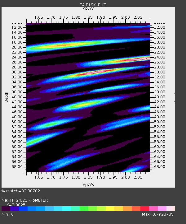
| Estimated Moho Depth: |
24.25 km |
| Estimated Crust Vp/Vs: |
2.08 |
| Assumed Crust Vp: |
6.577 km/s |
| Estimated Crust Vs: |
3.158 km/s |
| Estimated Crust Poisson's Ratio: |
0.35 |
|
| Radial Match: |
93.30782 % |
| Radial Bump: |
349 |
| Transverse Match: |
85.84579 % |
| Transverse Bump: |
400 |
| SOD ConfigId: |
13570011 |
| Insert Time: |
2019-05-01 04:28:23.456 +0000 |
| GWidth: |
2.5 |
| Max Bumps: |
400 |
| Tol: |
0.001 |
|

Signal To Noise
| Channel | StoN | STA | LTA |
| TA:E19K: :BHZ:20180908T07:28:17.29999Z | 4.555364 | 3.0310824E-7 | 6.6538746E-8 |
| TA:E19K: :BHN:20180908T07:28:17.29999Z | 1.0129187 | 5.207642E-8 | 5.1412243E-8 |
| TA:E19K: :BHE:20180908T07:28:17.29999Z | 2.9663599 | 1.00651214E-7 | 3.3930885E-8 |
| Arrivals |
| Ps | 4.1 SECOND |
| PpPs | 11 SECOND |
| PsPs/PpSs | 15 SECOND |


