You are here: Home > Network List > TA - USArray Transportable Network (new EarthScope stations) Stations List
> Station A13A Flathead National Forest, Polebridge, MT, USA > Earthquake Result Viewer
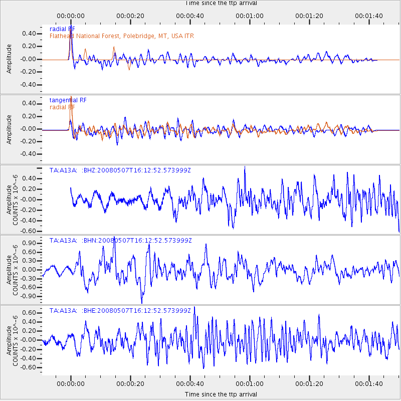
A13A Flathead National Forest, Polebridge, MT, USA - Earthquake Result Viewer
*The percent match for this event was below the threshold and hence no stack was calculated.
| Earthquake location: |
Near East Coast Of Honshu, Japan |
| Earthquake latitude/longitude: |
36.2/141.5 |
| Earthquake time(UTC): |
2008/05/07 (128) 16:02:02 GMT |
| Earthquake Depth: |
19 km |
| Earthquake Magnitude: |
5.7 MB, 6.2 MW, 6.2 MW |
| Earthquake Catalog/Contributor: |
WHDF/NEIC |
|
| Network: |
TA USArray Transportable Network (new EarthScope stations) |
| Station: |
A13A Flathead National Forest, Polebridge, MT, USA |
| Lat/Lon: |
48.93 N/114.41 W |
| Elevation: |
1199 m |
|
| Distance: |
71.8 deg |
| Az: |
42.333 deg |
| Baz: |
304.286 deg |
| Ray Param: |
$rayparam |
*The percent match for this event was below the threshold and hence was not used in the summary stack. |
|
| Radial Match: |
79.18617 % |
| Radial Bump: |
400 |
| Transverse Match: |
76.80683 % |
| Transverse Bump: |
400 |
| SOD ConfigId: |
2504 |
| Insert Time: |
2010-03-06 15:34:04.874 +0000 |
| GWidth: |
2.5 |
| Max Bumps: |
400 |
| Tol: |
0.001 |
|
Signal To Noise
| Channel | StoN | STA | LTA |
| TA:A13A: :BHN:20080507T16:12:52.573999Z | 3.0651045 | 2.558391E-7 | 8.3468315E-8 |
| TA:A13A: :BHE:20080507T16:12:52.573999Z | 2.8301005 | 1.8359432E-7 | 6.487201E-8 |
| TA:A13A: :BHZ:20080507T16:12:52.573999Z | 1.7957662 | 1.5497852E-7 | 8.630217E-8 |
| Arrivals |
| Ps | |
| PpPs | |
| PsPs/PpSs | |


