You are here: Home > Network List > TA - USArray Transportable Network (new EarthScope stations) Stations List
> Station G21K Allakaket, AK, USA > Earthquake Result Viewer
G21K Allakaket, AK, USA - Earthquake Result Viewer
| Earthquake location: |
Mindanao, Philippines |
| Earthquake latitude/longitude: |
7.2/126.5 |
| Earthquake time(UTC): |
2018/09/08 (251) 07:16:49 GMT |
| Earthquake Depth: |
10 km |
| Earthquake Magnitude: |
6.1 Mww |
| Earthquake Catalog/Contributor: |
NEIC PDE/us |
|
| Network: |
TA USArray Transportable Network (new EarthScope stations) |
| Station: |
G21K Allakaket, AK, USA |
| Lat/Lon: |
66.52 N/153.51 W |
| Elevation: |
446 m |
|
| Distance: |
79.4 deg |
| Az: |
23.674 deg |
| Baz: |
263.742 deg |
| Ray Param: |
0.048969824 |
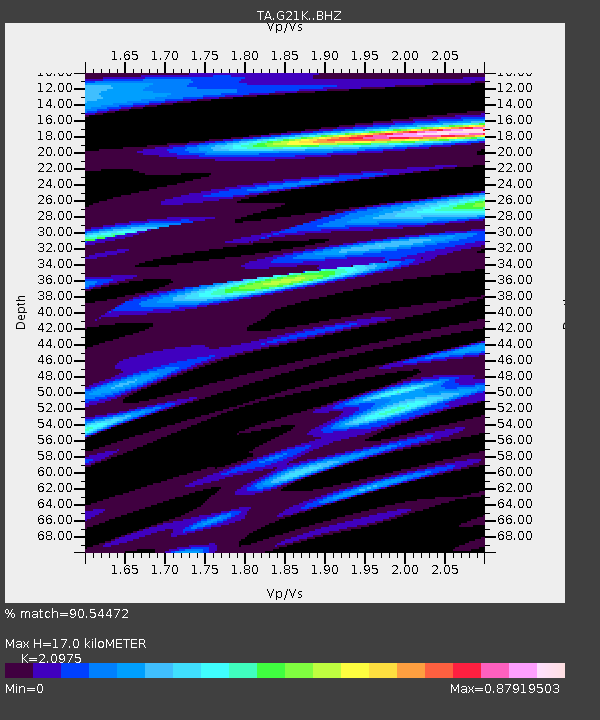
| Estimated Moho Depth: |
17.0 km |
| Estimated Crust Vp/Vs: |
2.10 |
| Assumed Crust Vp: |
6.455 km/s |
| Estimated Crust Vs: |
3.078 km/s |
| Estimated Crust Poisson's Ratio: |
0.35 |
|
| Radial Match: |
90.54472 % |
| Radial Bump: |
400 |
| Transverse Match: |
82.49187 % |
| Transverse Bump: |
400 |
| SOD ConfigId: |
13570011 |
| Insert Time: |
2019-05-01 04:28:42.549 +0000 |
| GWidth: |
2.5 |
| Max Bumps: |
400 |
| Tol: |
0.001 |
|

Signal To Noise
| Channel | StoN | STA | LTA |
| TA:G21K: :BHZ:20180908T07:28:24.525027Z | 5.2946815 | 2.3745038E-7 | 4.4846963E-8 |
| TA:G21K: :BHN:20180908T07:28:24.525027Z | 0.6027705 | 3.407424E-8 | 5.6529373E-8 |
| TA:G21K: :BHE:20180908T07:28:24.525027Z | 1.1357576 | 6.592558E-8 | 5.804547E-8 |
| Arrivals |
| Ps | 3.0 SECOND |
| PpPs | 8.0 SECOND |
| PsPs/PpSs | 11 SECOND |


