You are here: Home > Network List > TA - USArray Transportable Network (new EarthScope stations) Stations List
> Station G23K Bananza Creek, AK, USA > Earthquake Result Viewer
G23K Bananza Creek, AK, USA - Earthquake Result Viewer
| Earthquake location: |
Mindanao, Philippines |
| Earthquake latitude/longitude: |
7.2/126.5 |
| Earthquake time(UTC): |
2018/09/08 (251) 07:16:49 GMT |
| Earthquake Depth: |
10 km |
| Earthquake Magnitude: |
6.1 Mww |
| Earthquake Catalog/Contributor: |
NEIC PDE/us |
|
| Network: |
TA USArray Transportable Network (new EarthScope stations) |
| Station: |
G23K Bananza Creek, AK, USA |
| Lat/Lon: |
66.71 N/150.02 W |
| Elevation: |
746 m |
|
| Distance: |
80.8 deg |
| Az: |
23.59 deg |
| Baz: |
266.92 deg |
| Ray Param: |
0.04801363 |
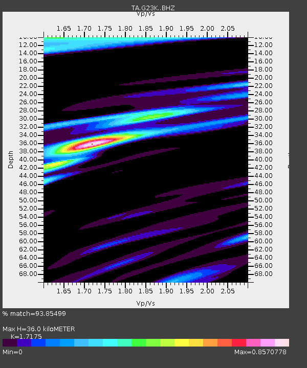
| Estimated Moho Depth: |
36.0 km |
| Estimated Crust Vp/Vs: |
1.72 |
| Assumed Crust Vp: |
6.577 km/s |
| Estimated Crust Vs: |
3.829 km/s |
| Estimated Crust Poisson's Ratio: |
0.24 |
|
| Radial Match: |
93.85499 % |
| Radial Bump: |
331 |
| Transverse Match: |
78.76611 % |
| Transverse Bump: |
400 |
| SOD ConfigId: |
13570011 |
| Insert Time: |
2019-05-01 04:28:44.747 +0000 |
| GWidth: |
2.5 |
| Max Bumps: |
400 |
| Tol: |
0.001 |
|

Signal To Noise
| Channel | StoN | STA | LTA |
| TA:G23K: :BHZ:20180908T07:28:32.04999Z | 3.9822826 | 2.2615792E-7 | 5.679103E-8 |
| TA:G23K: :BHN:20180908T07:28:32.04999Z | 0.8824977 | 4.4958163E-8 | 5.0944227E-8 |
| TA:G23K: :BHE:20180908T07:28:32.04999Z | 1.8355029 | 8.170143E-8 | 4.451174E-8 |
| Arrivals |
| Ps | 4.0 SECOND |
| PpPs | 14 SECOND |
| PsPs/PpSs | 18 SECOND |


