You are here: Home > Network List > TA - USArray Transportable Network (new EarthScope stations) Stations List
> Station K20K Telida, AK, USA > Earthquake Result Viewer
K20K Telida, AK, USA - Earthquake Result Viewer
| Earthquake location: |
Mindanao, Philippines |
| Earthquake latitude/longitude: |
7.2/126.5 |
| Earthquake time(UTC): |
2018/09/08 (251) 07:16:49 GMT |
| Earthquake Depth: |
10 km |
| Earthquake Magnitude: |
6.1 Mww |
| Earthquake Catalog/Contributor: |
NEIC PDE/us |
|
| Network: |
TA USArray Transportable Network (new EarthScope stations) |
| Station: |
K20K Telida, AK, USA |
| Lat/Lon: |
63.36 N/154.07 W |
| Elevation: |
548 m |
|
| Distance: |
78.8 deg |
| Az: |
26.858 deg |
| Baz: |
263.832 deg |
| Ray Param: |
0.04936729 |
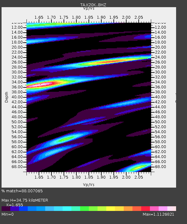
| Estimated Moho Depth: |
34.75 km |
| Estimated Crust Vp/Vs: |
1.65 |
| Assumed Crust Vp: |
6.438 km/s |
| Estimated Crust Vs: |
3.89 km/s |
| Estimated Crust Poisson's Ratio: |
0.21 |
|
| Radial Match: |
88.007065 % |
| Radial Bump: |
377 |
| Transverse Match: |
75.82396 % |
| Transverse Bump: |
400 |
| SOD ConfigId: |
13570011 |
| Insert Time: |
2019-05-01 04:29:10.454 +0000 |
| GWidth: |
2.5 |
| Max Bumps: |
400 |
| Tol: |
0.001 |
|

Signal To Noise
| Channel | StoN | STA | LTA |
| TA:K20K: :BHZ:20180908T07:28:21.325015Z | 2.5908325 | 1.9790848E-7 | 7.638799E-8 |
| TA:K20K: :BHN:20180908T07:28:21.325015Z | 0.8028187 | 3.6796408E-8 | 4.5834017E-8 |
| TA:K20K: :BHE:20180908T07:28:21.325015Z | 1.8691725 | 8.524155E-8 | 4.5603898E-8 |
| Arrivals |
| Ps | 3.6 SECOND |
| PpPs | 14 SECOND |
| PsPs/PpSs | 18 SECOND |


