You are here: Home > Network List > TA - USArray Transportable Network (new EarthScope stations) Stations List
> Station M17K Holitna River, AK, USA > Earthquake Result Viewer
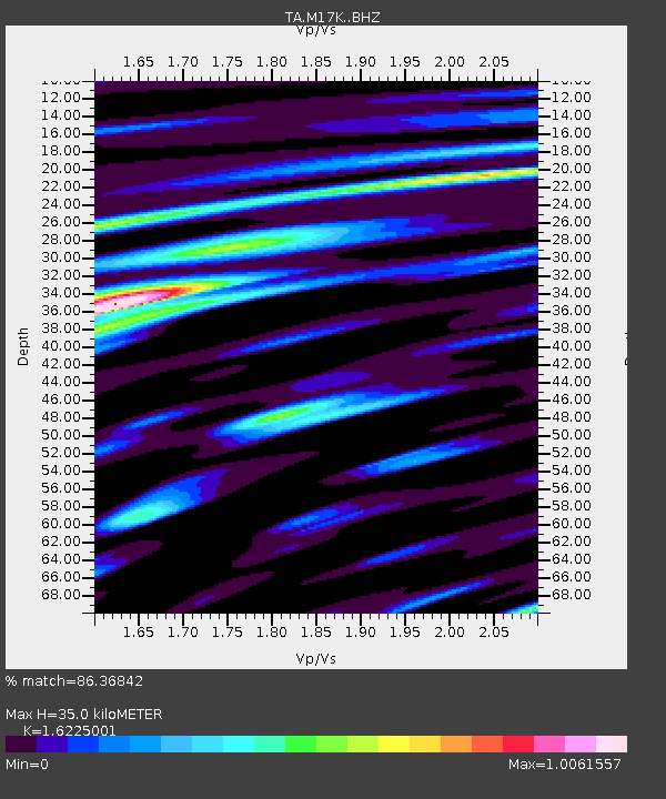
M17K Holitna River, AK, USA - Earthquake Result Viewer
| Earthquake location: |
Mindanao, Philippines |
| Earthquake latitude/longitude: |
7.2/126.5 |
| Earthquake time(UTC): |
2018/09/08 (251) 07:16:49 GMT |
| Earthquake Depth: |
10 km |
| Earthquake Magnitude: |
6.1 Mww |
| Earthquake Catalog/Contributor: |
NEIC PDE/us |
|
| Network: |
TA USArray Transportable Network (new EarthScope stations) |
| Station: |
M17K Holitna River, AK, USA |
| Lat/Lon: |
61.40 N/157.44 W |
| Elevation: |
387 m |
|
| Distance: |
77.0 deg |
| Az: |
28.64 deg |
| Baz: |
261.224 deg |
| Ray Param: |
0.050596274 |
| Estimated Moho Depth: |
35.0 km |
| Estimated Crust Vp/Vs: |
1.62 |
| Assumed Crust Vp: |
6.155 km/s |
| Estimated Crust Vs: |
3.793 km/s |
| Estimated Crust Poisson's Ratio: |
0.19 |
|
| Radial Match: |
86.36842 % |
| Radial Bump: |
400 |
| Transverse Match: |
75.32402 % |
| Transverse Bump: |
400 |
| SOD ConfigId: |
13570011 |
| Insert Time: |
2019-05-01 04:29:23.128 +0000 |
| GWidth: |
2.5 |
| Max Bumps: |
400 |
| Tol: |
0.001 |
|

Signal To Noise
| Channel | StoN | STA | LTA |
| TA:M17K: :BHZ:20180908T07:28:11.29999Z | 3.6674361 | 3.4151574E-7 | 9.3121116E-8 |
| TA:M17K: :BHN:20180908T07:28:11.29999Z | 1.434102 | 1.6087812E-7 | 1.1218039E-7 |
| TA:M17K: :BHE:20180908T07:28:11.29999Z | 0.66628915 | 7.91801E-8 | 1.1883745E-7 |
| Arrivals |
| Ps | 3.7 SECOND |
| PpPs | 14 SECOND |
| PsPs/PpSs | 18 SECOND |


