You are here: Home > Network List > AZ - ANZA Regional Network Stations List
> Station FRD AZ.FRD > Earthquake Result Viewer
FRD AZ.FRD - Earthquake Result Viewer
*The percent match for this event was below the threshold and hence no stack was calculated.
| Earthquake location: |
Southeast Of Loyalty Islands |
| Earthquake latitude/longitude: |
-22.2/170.2 |
| Earthquake time(UTC): |
2018/09/08 (251) 10:02:49 GMT |
| Earthquake Depth: |
10 km |
| Earthquake Magnitude: |
5.7 Mww |
| Earthquake Catalog/Contributor: |
NEIC PDE/us |
|
| Network: |
AZ ANZA Regional Network |
| Station: |
FRD AZ.FRD |
| Lat/Lon: |
33.49 N/116.60 W |
| Elevation: |
1164 m |
|
| Distance: |
89.0 deg |
| Az: |
53.156 deg |
| Baz: |
242.548 deg |
| Ray Param: |
$rayparam |
*The percent match for this event was below the threshold and hence was not used in the summary stack. |
|
| Radial Match: |
55.632614 % |
| Radial Bump: |
400 |
| Transverse Match: |
51.742012 % |
| Transverse Bump: |
400 |
| SOD ConfigId: |
13570011 |
| Insert Time: |
2019-05-01 04:32:11.949 +0000 |
| GWidth: |
2.5 |
| Max Bumps: |
400 |
| Tol: |
0.001 |
|
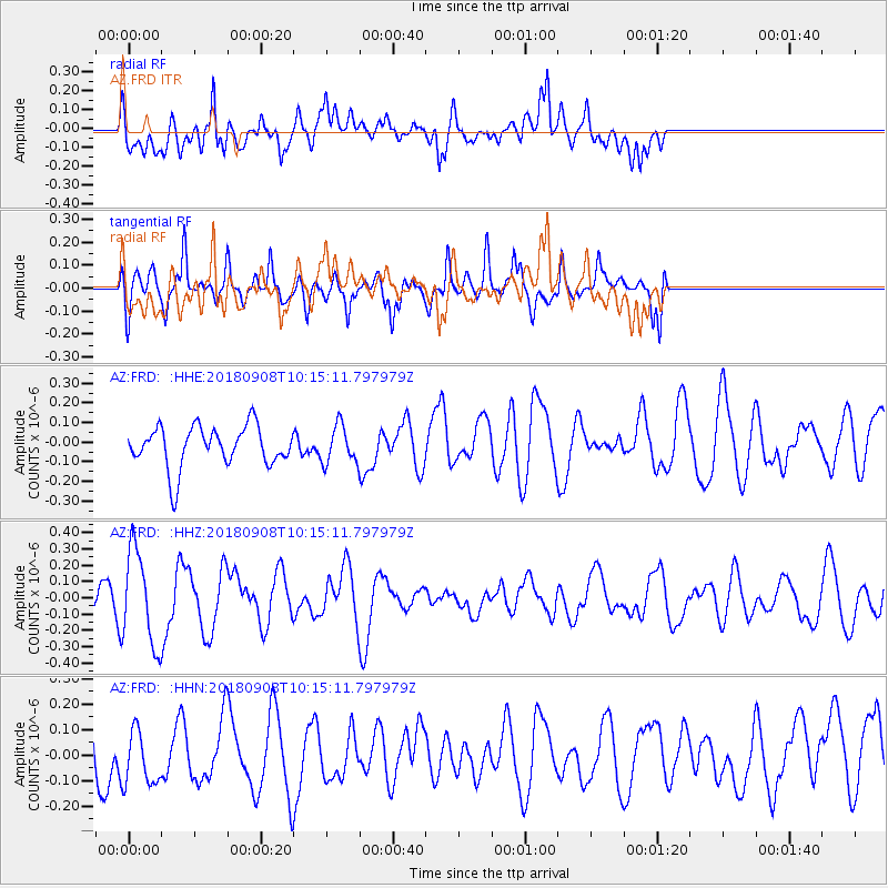
Signal To Noise
| Channel | StoN | STA | LTA |
| AZ:FRD: :HHZ:20180908T10:15:11.797979Z | 2.3363616 | 2.9133034E-7 | 1.2469403E-7 |
| AZ:FRD: :HHN:20180908T10:15:11.797979Z | 0.94088525 | 1.16764696E-7 | 1.241009E-7 |
| AZ:FRD: :HHE:20180908T10:15:11.797979Z | 1.0568204 | 1.1108549E-7 | 1.0511293E-7 |
| Arrivals |
| Ps | |
| PpPs | |
| PsPs/PpSs | |


