You are here: Home > Network List > TA - USArray Transportable Network (new EarthScope stations) Stations List
> Station A13A Flathead National Forest, Polebridge, MT, USA > Earthquake Result Viewer
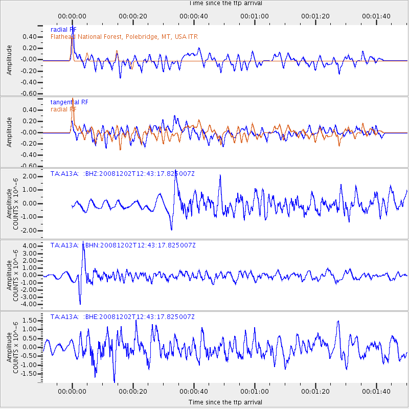
A13A Flathead National Forest, Polebridge, MT, USA - Earthquake Result Viewer
*The percent match for this event was below the threshold and hence no stack was calculated.
| Earthquake location: |
Mariana Islands |
| Earthquake latitude/longitude: |
19.1/145.8 |
| Earthquake time(UTC): |
2008/12/02 (337) 12:31:43 GMT |
| Earthquake Depth: |
137 km |
| Earthquake Magnitude: |
5.9 MB, 5.9 MW, 5.9 MW |
| Earthquake Catalog/Contributor: |
WHDF/NEIC |
|
| Network: |
TA USArray Transportable Network (new EarthScope stations) |
| Station: |
A13A Flathead National Forest, Polebridge, MT, USA |
| Lat/Lon: |
48.93 N/114.41 W |
| Elevation: |
1199 m |
|
| Distance: |
82.1 deg |
| Az: |
40.998 deg |
| Baz: |
289.832 deg |
| Ray Param: |
$rayparam |
*The percent match for this event was below the threshold and hence was not used in the summary stack. |
|
| Radial Match: |
69.5789 % |
| Radial Bump: |
400 |
| Transverse Match: |
57.45085 % |
| Transverse Bump: |
400 |
| SOD ConfigId: |
2658 |
| Insert Time: |
2010-03-06 15:34:42.210 +0000 |
| GWidth: |
2.5 |
| Max Bumps: |
400 |
| Tol: |
0.001 |
|
Signal To Noise
| Channel | StoN | STA | LTA |
| TA:A13A: :BHN:20081202T12:43:17.825007Z | 5.0893054 | 1.8699761E-6 | 3.674325E-7 |
| TA:A13A: :BHE:20081202T12:43:17.825007Z | 1.2186352 | 4.2998673E-7 | 3.5284287E-7 |
| TA:A13A: :BHZ:20081202T12:43:17.825007Z | 4.9591527 | 1.1300325E-6 | 2.2786807E-7 |
| Arrivals |
| Ps | |
| PpPs | |
| PsPs/PpSs | |


