You are here: Home > Network List > TA - USArray Transportable Network (new EarthScope stations) Stations List
> Station A13A Flathead National Forest, Polebridge, MT, USA > Earthquake Result Viewer
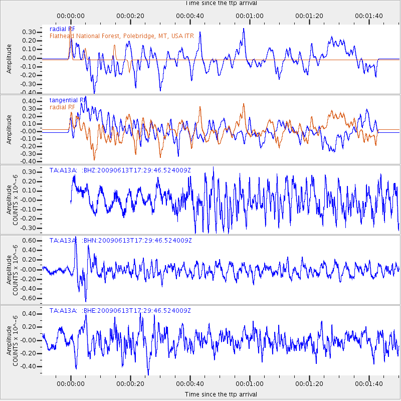
A13A Flathead National Forest, Polebridge, MT, USA - Earthquake Result Viewer
*The percent match for this event was below the threshold and hence no stack was calculated.
| Earthquake location: |
Eastern Kazakhstan |
| Earthquake latitude/longitude: |
44.7/78.9 |
| Earthquake time(UTC): |
2009/06/13 (164) 17:17:38 GMT |
| Earthquake Depth: |
14 km |
| Earthquake Magnitude: |
5.8 MB, 5.1 MS, 5.4 MW, 5.4 MW |
| Earthquake Catalog/Contributor: |
WHDF/NEIC |
|
| Network: |
TA USArray Transportable Network (new EarthScope stations) |
| Station: |
A13A Flathead National Forest, Polebridge, MT, USA |
| Lat/Lon: |
48.93 N/114.41 W |
| Elevation: |
1199 m |
|
| Distance: |
86.0 deg |
| Az: |
8.733 deg |
| Baz: |
350.554 deg |
| Ray Param: |
$rayparam |
*The percent match for this event was below the threshold and hence was not used in the summary stack. |
|
| Radial Match: |
65.526146 % |
| Radial Bump: |
400 |
| Transverse Match: |
38.747734 % |
| Transverse Bump: |
400 |
| SOD ConfigId: |
2648 |
| Insert Time: |
2010-03-06 15:34:51.978 +0000 |
| GWidth: |
2.5 |
| Max Bumps: |
400 |
| Tol: |
0.001 |
|
Signal To Noise
| Channel | StoN | STA | LTA |
| TA:A13A: :BHN:20090613T17:29:46.524009Z | 2.6826756 | 2.6024253E-7 | 9.7008574E-8 |
| TA:A13A: :BHE:20090613T17:29:46.524009Z | 1.9665543 | 1.8634033E-7 | 9.475473E-8 |
| TA:A13A: :BHZ:20090613T17:29:46.524009Z | 0.8939587 | 8.7538524E-8 | 9.792234E-8 |
| Arrivals |
| Ps | |
| PpPs | |
| PsPs/PpSs | |


