You are here: Home > Network List > TA - USArray Transportable Network (new EarthScope stations) Stations List
> Station J26L Joseph Creek, AK, USA > Earthquake Result Viewer
J26L Joseph Creek, AK, USA - Earthquake Result Viewer
*The percent match for this event was below the threshold and hence no stack was calculated.
| Earthquake location: |
Southeast Of Loyalty Islands |
| Earthquake latitude/longitude: |
-22.2/170.2 |
| Earthquake time(UTC): |
2018/09/08 (251) 10:02:49 GMT |
| Earthquake Depth: |
10 km |
| Earthquake Magnitude: |
5.7 Mww |
| Earthquake Catalog/Contributor: |
NEIC PDE/us |
|
| Network: |
TA USArray Transportable Network (new EarthScope stations) |
| Station: |
J26L Joseph Creek, AK, USA |
| Lat/Lon: |
64.50 N/143.56 W |
| Elevation: |
1144 m |
|
| Distance: |
93.5 deg |
| Az: |
18.267 deg |
| Baz: |
222.145 deg |
| Ray Param: |
$rayparam |
*The percent match for this event was below the threshold and hence was not used in the summary stack. |
|
| Radial Match: |
64.67395 % |
| Radial Bump: |
400 |
| Transverse Match: |
59.557087 % |
| Transverse Bump: |
400 |
| SOD ConfigId: |
13570011 |
| Insert Time: |
2019-05-01 04:35:51.416 +0000 |
| GWidth: |
2.5 |
| Max Bumps: |
400 |
| Tol: |
0.001 |
|
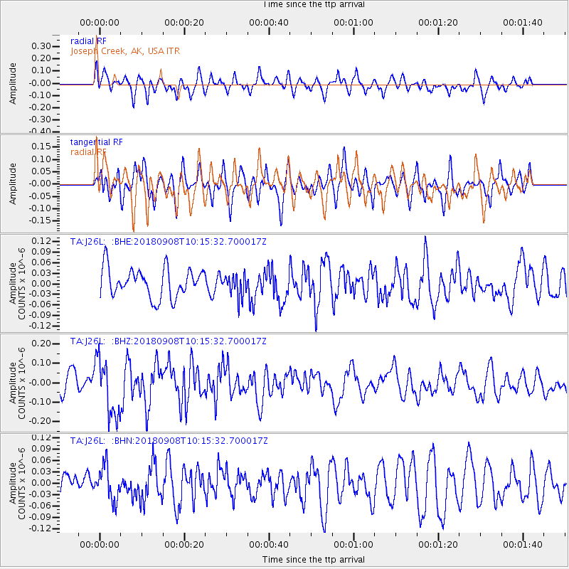
Signal To Noise
| Channel | StoN | STA | LTA |
| TA:J26L: :BHZ:20180908T10:15:32.700017Z | 2.2101161 | 1.4865562E-7 | 6.726145E-8 |
| TA:J26L: :BHN:20180908T10:15:32.700017Z | 1.6048863 | 4.577183E-8 | 2.8520295E-8 |
| TA:J26L: :BHE:20180908T10:15:32.700017Z | 0.8940225 | 3.664417E-8 | 4.098797E-8 |
| Arrivals |
| Ps | |
| PpPs | |
| PsPs/PpSs | |


