You are here: Home > Network List > UW - Pacific Northwest Regional Seismic Network Stations List
> Station UMAT Pilot Rock, OR, USA > Earthquake Result Viewer
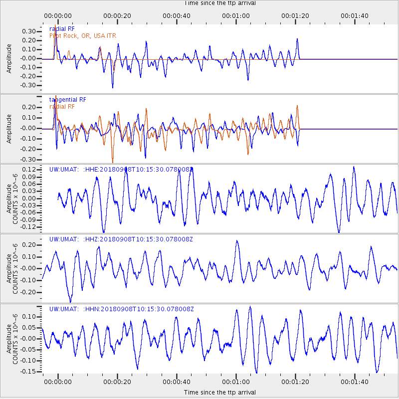
UMAT Pilot Rock, OR, USA - Earthquake Result Viewer
*The percent match for this event was below the threshold and hence no stack was calculated.
| Earthquake location: |
Southeast Of Loyalty Islands |
| Earthquake latitude/longitude: |
-22.2/170.2 |
| Earthquake time(UTC): |
2018/09/08 (251) 10:02:49 GMT |
| Earthquake Depth: |
10 km |
| Earthquake Magnitude: |
5.7 Mww |
| Earthquake Catalog/Contributor: |
NEIC PDE/us |
|
| Network: |
UW Pacific Northwest Regional Seismic Network |
| Station: |
UMAT Pilot Rock, OR, USA |
| Lat/Lon: |
45.29 N/118.96 W |
| Elevation: |
1318 m |
|
| Distance: |
93.0 deg |
| Az: |
41.905 deg |
| Baz: |
241.25 deg |
| Ray Param: |
$rayparam |
*The percent match for this event was below the threshold and hence was not used in the summary stack. |
|
| Radial Match: |
66.00516 % |
| Radial Bump: |
338 |
| Transverse Match: |
44.502098 % |
| Transverse Bump: |
381 |
| SOD ConfigId: |
13570011 |
| Insert Time: |
2019-05-01 04:37:25.360 +0000 |
| GWidth: |
2.5 |
| Max Bumps: |
400 |
| Tol: |
0.001 |
|
Signal To Noise
| Channel | StoN | STA | LTA |
| UW:UMAT: :HHZ:20180908T10:15:30.078008Z | 3.261578 | 1.4417463E-7 | 4.420395E-8 |
| UW:UMAT: :HHN:20180908T10:15:30.078008Z | 0.38396546 | 2.319428E-8 | 6.04072E-8 |
| UW:UMAT: :HHE:20180908T10:15:30.078008Z | 0.79258937 | 4.444584E-8 | 5.6076757E-8 |
| Arrivals |
| Ps | |
| PpPs | |
| PsPs/PpSs | |


