You are here: Home > Network List > TA - USArray Transportable Network (new EarthScope stations) Stations List
> Station A13A Flathead National Forest, Polebridge, MT, USA > Earthquake Result Viewer
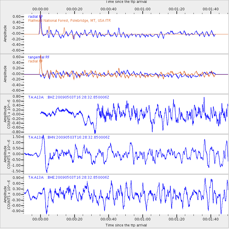
A13A Flathead National Forest, Polebridge, MT, USA - Earthquake Result Viewer
*The percent match for this event was below the threshold and hence no stack was calculated.
| Earthquake location: |
Guatemala |
| Earthquake latitude/longitude: |
14.6/-91.2 |
| Earthquake time(UTC): |
2009/05/03 (123) 16:21:47 GMT |
| Earthquake Depth: |
124 km |
| Earthquake Magnitude: |
5.6 MB, 6.2 MW, 6.2 MW |
| Earthquake Catalog/Contributor: |
WHDF/NEIC |
|
| Network: |
TA USArray Transportable Network (new EarthScope stations) |
| Station: |
A13A Flathead National Forest, Polebridge, MT, USA |
| Lat/Lon: |
48.93 N/114.41 W |
| Elevation: |
1199 m |
|
| Distance: |
39.2 deg |
| Az: |
335.7 deg |
| Baz: |
142.828 deg |
| Ray Param: |
$rayparam |
*The percent match for this event was below the threshold and hence was not used in the summary stack. |
|
| Radial Match: |
70.09179 % |
| Radial Bump: |
400 |
| Transverse Match: |
53.372395 % |
| Transverse Bump: |
400 |
| SOD ConfigId: |
2658 |
| Insert Time: |
2010-03-06 15:35:30.524 +0000 |
| GWidth: |
2.5 |
| Max Bumps: |
400 |
| Tol: |
0.001 |
|
Signal To Noise
| Channel | StoN | STA | LTA |
| TA:A13A: :BHN:20090503T16:28:32.850006Z | 12.978615 | 1.0020707E-6 | 7.720937E-8 |
| TA:A13A: :BHE:20090503T16:28:32.850006Z | 4.018107 | 4.2287843E-7 | 1.05243195E-7 |
| TA:A13A: :BHZ:20090503T16:28:32.850006Z | 5.520102 | 5.176721E-7 | 9.377945E-8 |
| Arrivals |
| Ps | |
| PpPs | |
| PsPs/PpSs | |


