You are here: Home > Network List > TA - USArray Transportable Network (new EarthScope stations) Stations List
> Station E15A Deer Lodge, MT, USA > Earthquake Result Viewer
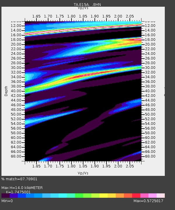
E15A Deer Lodge, MT, USA - Earthquake Result Viewer
| Earthquake location: |
Guatemala |
| Earthquake latitude/longitude: |
14.6/-91.2 |
| Earthquake time(UTC): |
2009/05/03 (123) 16:21:47 GMT |
| Earthquake Depth: |
124 km |
| Earthquake Magnitude: |
5.6 MB, 6.2 MW, 6.2 MW |
| Earthquake Catalog/Contributor: |
WHDF/NEIC |
|
| Network: |
TA USArray Transportable Network (new EarthScope stations) |
| Station: |
E15A Deer Lodge, MT, USA |
| Lat/Lon: |
46.42 N/112.64 W |
| Elevation: |
1520 m |
|
| Distance: |
36.5 deg |
| Az: |
334.808 deg |
| Baz: |
143.43 deg |
| Ray Param: |
0.07622934 |
| Estimated Moho Depth: |
14.0 km |
| Estimated Crust Vp/Vs: |
1.75 |
| Assumed Crust Vp: |
6.353 km/s |
| Estimated Crust Vs: |
3.635 km/s |
| Estimated Crust Poisson's Ratio: |
0.26 |
|
| Radial Match: |
87.78901 % |
| Radial Bump: |
254 |
| Transverse Match: |
50.7247 % |
| Transverse Bump: |
385 |
| SOD ConfigId: |
2760 |
| Insert Time: |
2010-03-06 15:36:51.653 +0000 |
| GWidth: |
2.5 |
| Max Bumps: |
400 |
| Tol: |
0.001 |
|

Signal To Noise
| Channel | StoN | STA | LTA |
| TA:E15A: :BHN:20090503T16:28:10.000Z | 9.158484 | 9.132444E-7 | 9.971566E-8 |
| TA:E15A: :BHE:20090503T16:28:10.000Z | 5.4537754 | 4.826706E-7 | 8.8502105E-8 |
| TA:E15A: :BHZ:20090503T16:28:10.000Z | 2.0726395 | 2.2047888E-7 | 1.0637589E-7 |
| Arrivals |
| Ps | 1.8 SECOND |
| PpPs | 5.6 SECOND |
| PsPs/PpSs | 7.4 SECOND |


