You are here: Home > Network List > TA - USArray Transportable Network (new EarthScope stations) Stations List
> Station E15A Deer Lodge, MT, USA > Earthquake Result Viewer
E15A Deer Lodge, MT, USA - Earthquake Result Viewer
| Earthquake location: |
South Of Mariana Islands |
| Earthquake latitude/longitude: |
10.5/145.7 |
| Earthquake time(UTC): |
2007/09/30 (273) 02:08:30 GMT |
| Earthquake Depth: |
14 km |
| Earthquake Magnitude: |
6.4 MB, 7.1 MS, 6.9 MW, 6.9 MW |
| Earthquake Catalog/Contributor: |
WHDF/NEIC |
|
| Network: |
TA USArray Transportable Network (new EarthScope stations) |
| Station: |
E15A Deer Lodge, MT, USA |
| Lat/Lon: |
46.42 N/112.64 W |
| Elevation: |
1520 m |
|
| Distance: |
90.4 deg |
| Az: |
42.651 deg |
| Baz: |
285.547 deg |
| Ray Param: |
0.041674934 |
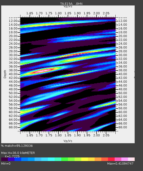
| Estimated Moho Depth: |
38.0 km |
| Estimated Crust Vp/Vs: |
1.72 |
| Assumed Crust Vp: |
6.353 km/s |
| Estimated Crust Vs: |
3.688 km/s |
| Estimated Crust Poisson's Ratio: |
0.25 |
|
| Radial Match: |
95.129036 % |
| Radial Bump: |
374 |
| Transverse Match: |
74.714676 % |
| Transverse Bump: |
400 |
| SOD ConfigId: |
2564 |
| Insert Time: |
2010-03-06 15:37:00.111 +0000 |
| GWidth: |
2.5 |
| Max Bumps: |
400 |
| Tol: |
0.001 |
|

Signal To Noise
| Channel | StoN | STA | LTA |
| TA:E15A: :BHN:20070930T02:20:59.399004Z | 0.76590395 | 1.7853651E-7 | 2.3310561E-7 |
| TA:E15A: :BHE:20070930T02:20:59.399004Z | 2.0824606 | 2.746553E-7 | 1.3188978E-7 |
| TA:E15A: :BHZ:20070930T02:20:59.399004Z | 3.8061218 | 7.136727E-7 | 1.8750653E-7 |
| Arrivals |
| Ps | 4.4 SECOND |
| PpPs | 16 SECOND |
| PsPs/PpSs | 20 SECOND |


