You are here: Home > Network List > TA - USArray Transportable Network (new EarthScope stations) Stations List
> Station E15A Deer Lodge, MT, USA > Earthquake Result Viewer
E15A Deer Lodge, MT, USA - Earthquake Result Viewer
| Earthquake location: |
Kuril Islands |
| Earthquake latitude/longitude: |
45.8/150.1 |
| Earthquake time(UTC): |
2007/09/03 (246) 16:14:53 GMT |
| Earthquake Depth: |
94 km |
| Earthquake Magnitude: |
6.3 MB, 6.2 MW, 6.2 ME |
| Earthquake Catalog/Contributor: |
WHDF/NEIC |
|
| Network: |
TA USArray Transportable Network (new EarthScope stations) |
| Station: |
E15A Deer Lodge, MT, USA |
| Lat/Lon: |
46.42 N/112.64 W |
| Elevation: |
1520 m |
|
| Distance: |
62.9 deg |
| Az: |
50.396 deg |
| Baz: |
308.859 deg |
| Ray Param: |
0.059647616 |
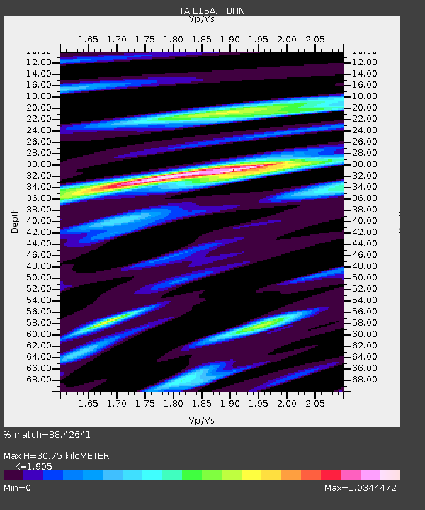
| Estimated Moho Depth: |
30.75 km |
| Estimated Crust Vp/Vs: |
1.90 |
| Assumed Crust Vp: |
6.353 km/s |
| Estimated Crust Vs: |
3.335 km/s |
| Estimated Crust Poisson's Ratio: |
0.31 |
|
| Radial Match: |
88.42641 % |
| Radial Bump: |
333 |
| Transverse Match: |
82.90268 % |
| Transverse Bump: |
400 |
| SOD ConfigId: |
2564 |
| Insert Time: |
2010-03-06 15:37:09.092 +0000 |
| GWidth: |
2.5 |
| Max Bumps: |
400 |
| Tol: |
0.001 |
|

Signal To Noise
| Channel | StoN | STA | LTA |
| TA:E15A: :BHN:20070903T16:24:39.374016Z | 8.663433 | 9.264202E-7 | 1.06934536E-7 |
| TA:E15A: :BHE:20070903T16:24:39.374016Z | 11.49795 | 1.0308855E-6 | 8.965821E-8 |
| TA:E15A: :BHZ:20070903T16:24:39.374016Z | 24.91041 | 2.4749772E-6 | 9.9355134E-8 |
| Arrivals |
| Ps | 4.6 SECOND |
| PpPs | 14 SECOND |
| PsPs/PpSs | 18 SECOND |


