You are here: Home > Network List > TA - USArray Transportable Network (new EarthScope stations) Stations List
> Station E15A Deer Lodge, MT, USA > Earthquake Result Viewer
E15A Deer Lodge, MT, USA - Earthquake Result Viewer
| Earthquake location: |
Tonga Islands |
| Earthquake latitude/longitude: |
-17.5/-174.3 |
| Earthquake time(UTC): |
2007/08/26 (238) 12:37:31 GMT |
| Earthquake Depth: |
127 km |
| Earthquake Magnitude: |
5.9 MB, 6.1 MW |
| Earthquake Catalog/Contributor: |
WHDF/NEIC |
|
| Network: |
TA USArray Transportable Network (new EarthScope stations) |
| Station: |
E15A Deer Lodge, MT, USA |
| Lat/Lon: |
46.42 N/112.64 W |
| Elevation: |
1520 m |
|
| Distance: |
84.4 deg |
| Az: |
37.731 deg |
| Baz: |
237.611 deg |
| Ray Param: |
0.04523059 |
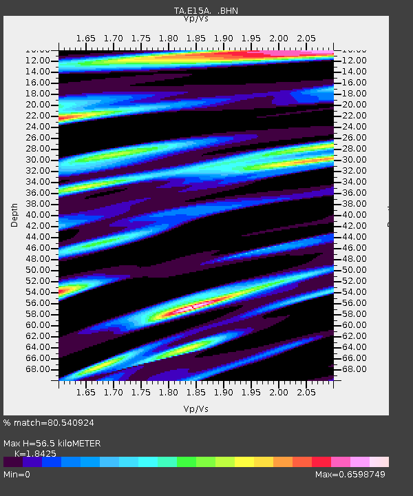
| Estimated Moho Depth: |
56.5 km |
| Estimated Crust Vp/Vs: |
1.84 |
| Assumed Crust Vp: |
6.353 km/s |
| Estimated Crust Vs: |
3.448 km/s |
| Estimated Crust Poisson's Ratio: |
0.29 |
|
| Radial Match: |
80.540924 % |
| Radial Bump: |
400 |
| Transverse Match: |
77.120605 % |
| Transverse Bump: |
400 |
| SOD ConfigId: |
2564 |
| Insert Time: |
2010-03-06 15:37:13.868 +0000 |
| GWidth: |
2.5 |
| Max Bumps: |
400 |
| Tol: |
0.001 |
|

Signal To Noise
| Channel | StoN | STA | LTA |
| TA:E15A: :BHN:20070826T12:49:18.124021Z | 5.2981377 | 1.9176959E-7 | 3.619566E-8 |
| TA:E15A: :BHE:20070826T12:49:18.124021Z | 8.114672 | 2.66267E-7 | 3.281303E-8 |
| TA:E15A: :BHZ:20070826T12:49:18.124021Z | 13.548319 | 7.086756E-7 | 5.230727E-8 |
| Arrivals |
| Ps | 7.7 SECOND |
| PpPs | 25 SECOND |
| PsPs/PpSs | 32 SECOND |


