You are here: Home > Network List > TA - USArray Transportable Network (new EarthScope stations) Stations List
> Station E15A Deer Lodge, MT, USA > Earthquake Result Viewer
E15A Deer Lodge, MT, USA - Earthquake Result Viewer
| Earthquake location: |
Komandorskiye Ostrova Region |
| Earthquake latitude/longitude: |
53.6/169.7 |
| Earthquake time(UTC): |
2007/07/29 (210) 04:54:36 GMT |
| Earthquake Depth: |
26 km |
| Earthquake Magnitude: |
6.0 MB, 5.5 MS, 5.9 MW, 5.8 MW |
| Earthquake Catalog/Contributor: |
WHDF/NEIC |
|
| Network: |
TA USArray Transportable Network (new EarthScope stations) |
| Station: |
E15A Deer Lodge, MT, USA |
| Lat/Lon: |
46.42 N/112.64 W |
| Elevation: |
1520 m |
|
| Distance: |
48.1 deg |
| Az: |
65.274 deg |
| Baz: |
308.57 deg |
| Ray Param: |
0.06955186 |
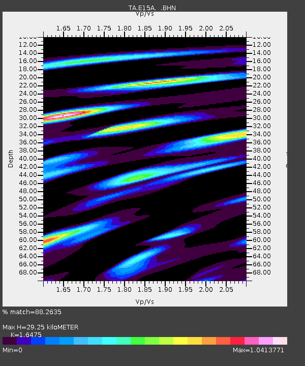
| Estimated Moho Depth: |
29.25 km |
| Estimated Crust Vp/Vs: |
1.65 |
| Assumed Crust Vp: |
6.353 km/s |
| Estimated Crust Vs: |
3.856 km/s |
| Estimated Crust Poisson's Ratio: |
0.21 |
|
| Radial Match: |
88.2635 % |
| Radial Bump: |
400 |
| Transverse Match: |
75.714874 % |
| Transverse Bump: |
400 |
| SOD ConfigId: |
2564 |
| Insert Time: |
2010-03-06 15:37:37.857 +0000 |
| GWidth: |
2.5 |
| Max Bumps: |
400 |
| Tol: |
0.001 |
|

Signal To Noise
| Channel | StoN | STA | LTA |
| TA:E15A: :BHN:20070729T05:02:43.173013Z | 1.8938049 | 1.1976415E-7 | 6.323996E-8 |
| TA:E15A: :BHE:20070729T05:02:43.173013Z | 3.8485863 | 1.10019876E-7 | 2.8587086E-8 |
| TA:E15A: :BHZ:20070729T05:02:43.173013Z | 4.3666825 | 3.485453E-7 | 7.9819245E-8 |
| Arrivals |
| Ps | 3.2 SECOND |
| PpPs | 11 SECOND |
| PsPs/PpSs | 15 SECOND |


